Succieu geodata
Succieu (Auvergne-Rhône-Alpes) is a populated place; located in France in Europe/Paris (GMT+2) time zone. With population of 597 people, there are 13370 cities with bigger population in this country. Compared to other cities in France, 73.8% of cities are located further ↑North; 81% of cities are located further ←West and 91.9% of cities have lower elevation than Succieu. Note1
Administrative division(s):
- Level 1: Auvergne-Rhône-Alpes
- Level 2: Département de l'Isère
- Level 3: Arrondissement de La Tour-du-Pin
- Level 4: Succieu


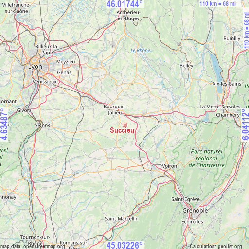
Succieu GPS coordinates[2]
45° 31' 37.236" North, 5° 20' 16.764" East
| Map corner | latitude | longitude |
|---|---|---|
| Upper-left | 46.01744°, | 4.63487° |
| Center: | 45.52701°, | 5.33799° |
| Lower-right: | 45.03226°, | 6.04112° |
| Map W x H: | 109.5×109.5 km | = 68×68mi |
| max Lat: | 51.07786° ⇑73.8% North |
| Succieu: | 45.52701° |
| min Lat: | ⇓26.2% South 41.3874° |
| min Long | Succieu | max Long |
| -5.08615° | 5.33799° | 9.52242° |
| W 81%⇐ | ⇒19% E |
Elevation
Elevation of Succieu is 471 m = 1545 ft, and this is 277.3 m = 910 ft above average elevation for this country.
| Max E: |
2333 m = 7654 ft | 8.1% |
| Succieu | 471 m 1545 ft | |
| Avg. | 193.7 m = 635 ft | |
Min E: |
-1 m = -3 ft | 91.9% |
See also: France elevation on elevation.city.
Geographical zone
Succieu is located in North temperate zone (between Tropic of Cancer and the Arctic Circle). Distance of this North polar circle is 2339 km =1453.4 mi to North.| Distance of | km | miles | from Succieu |
|---|---|---|---|
| North Pole | 4944.9 | 3072.6 | to North |
| Arctic Circle | 2339 | 1453.4 | to North |
| Tropic Cancer | 2456.2 | 1526.2 | to South |
| Equator | 5062.1 | 3145.4 | to South |


Nearby cities:
15 places around Succieu: (largest is in red/bold)
• Badinières
3.5 km =2.2 mi,  232°
232°
• Biol
5.4 km =3.4 mi,  136°
136°
• Cessieu
5 km =3.1 mi,  36°
36°
• Châteauvilain
1.5 km =0.9 mi,  204°
204°
• Culin
6.7 km =4.2 mi,  267°
267°
• Doissin
6.7 km =4.2 mi,  113°
113°
• Eclose
4.4 km =2.7 mi,  223°
223°
• Les Éparres
3.5 km =2.2 mi,  287°
287°
• Maubec
7.3 km =4.5 mi,  307°
307°
• Meyrié
5.2 km =3.2 mi, 311°
• Nivolas-Vermelle
4.3 km =2.7 mi,  324°
324°
• Ruy
6.7 km =4.2 mi,  348°
348°
• Saint-Victor-de-Cessieu
4.4 km =2.7 mi,  69°
69°
• Sérézin-de-la-Tour
3.3 km =2.1 mi,  13°
13°
• Tramolé
5.5 km =3.4 mi,  259°
259°
Sources, notices
• [Note1] Compared only with cities in France existing in our database
• [Src1] Map data: © OpenStreetMap contributors (CC-BY-SA)
• [Src2] Other city data from geonames.org with taken over terms of usage.
• [Src3] Geographical zone / Annual Mean Temperature by Robert A. Rohde @ Wikipedia
