Aire-sur-la-Lys geodata
Aire-sur-la-Lys (Hauts-de-France) is a populated place; located in France in Europe/Paris (GMT+2) time zone. With population of 10,397 people, there are 914 cities with bigger population in this country. Compared to other cities in France, 98.4% of cities are located further ↓South; 51.1% of cities are located further →East and 92.4% of cities have higher elevation than Aire-sur-la-Lys. Note1
Administrative division(s):
- Level 1: Hauts-de-France
- Level 2: Pas-de-Calais
- Level 3: Arrondissement de Saint-Omer
- Level 4: Aire-sur-la-Lys


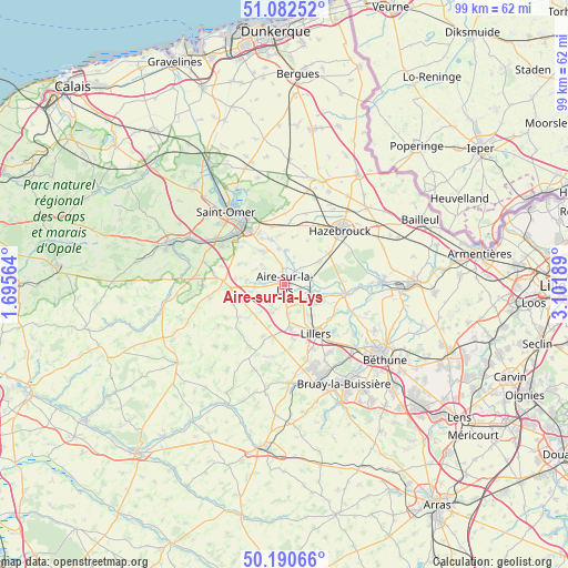
Aire-sur-la-Lys GPS coordinates[2]
50° 38' 19.356" North, 2° 23' 55.536" East
| Map corner | latitude | longitude |
|---|---|---|
| Upper-left | 51.08252°, | 1.69564° |
| Center: | 50.63871°, | 2.39876° |
| Lower-right: | 50.19066°, | 3.10189° |
| Map W x H: | 99.2×99.2 km | = 61.6×61.6mi |
| max Lat: | 51.07786° ⇑1.6% North |
| Aire-sur-la-Lys: | 50.63871° |
| min Lat: | ⇓98.4% South 41.3874° |
| min Long | Aire-sur-la-Lys | max Long |
| -5.08615° | 2.39876° | 9.52242° |
| W 48.9%⇐ | ⇒51.1% E |
Elevation
Elevation of Aire-sur-la-Lys is 24 m = 79 ft, and this is 169.7 m = 557 ft below average elevation for this country.
| Max E: |
2333 m = 7654 ft | 92.4% |
| Avg. | 193.7 m = 635 ft | |
| Aire-sur-la-Lys | 24 m = 79 ft | |
Min E: |
-1 m = -3 ft | 7.6% |
See also: France elevation on elevation.city.
Geographical zone
Aire-sur-la-Lys is located in North temperate zone (between Tropic of Cancer and the Arctic Circle). Distance of this North polar circle is 1770.7 km =1100.3 mi to North.| Distance of | km | miles | from Aire-sur-la-Lys |
|---|---|---|---|
| North Pole | 4376.6 | 2719.5 | to North |
| Arctic Circle | 1770.7 | 1100.3 | to North |
| Tropic Cancer | 3024.6 | 1879.4 | to South |
| Equator | 5630.5 | 3498.6 | to South |


Nearby cities:
15 places around Aire-sur-la-Lys: (largest is in red/bold)
• Blaringhem
5.8 km =3.6 mi,  3°
3°
• Blessy
5.3 km =3.3 mi,  242°
242°
• Guarbecque
7 km =4.3 mi,  115°
115°
• Ham-en-Artois
6.9 km =4.3 mi,  142°
142°
• Isbergues
4.6 km =2.9 mi,  111°
111°
• Lambres
2.3 km =1.4 mi,  184°
184°
• Mametz
5.2 km =3.2 mi,  265°
265°
• Norrent-Fontes
6.2 km =3.9 mi, 179°
• Quiestède
6.6 km =4.1 mi,  315°
315°
• Racquinghem
6.6 km =4.1 mi,  333°
333°
• Roquetoire
5.3 km =3.3 mi,  311°
311°
• Steenbecque
7.2 km =4.5 mi,  56°
56°
• Thiennes
5 km =3.1 mi,  73°
73°
• Witternesse
4.2 km =2.6 mi,  219°
219°
• Wittes
3.5 km =2.2 mi,  351°
351°
Sources, notices
• [Note1] Compared only with cities in France existing in our database
• [Src1] Map data: © OpenStreetMap contributors (CC-BY-SA)
• [Src2] Other city data from geonames.org with taken over terms of usage.
• [Src3] Geographical zone / Annual Mean Temperature by Robert A. Rohde @ Wikipedia
