Guarbecque geodata
Guarbecque (Hauts-de-France) is a populated place; located in France in Europe/Paris (GMT+2) time zone. With population of 1,299 people, there are 7036 cities with bigger population in this country. Compared to other cities in France, 98.2% of cities are located further ↓South; 50.4% of cities are located further ←West and 93.9% of cities have higher elevation than Guarbecque. Note1
Administrative division(s):
- Level 1: Hauts-de-France
- Level 2: Pas-de-Calais
- Level 3: Arrondissement de Béthune
- Level 4: Guarbecque


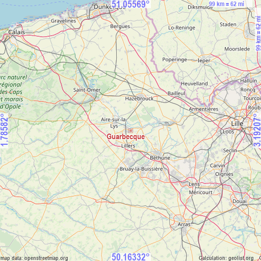
Guarbecque GPS coordinates[2]
50° 36' 41.832" North, 2° 29' 20.22" East
| Map corner | latitude | longitude |
|---|---|---|
| Upper-left | 51.05569°, | 1.78582° |
| Center: | 50.61162°, | 2.48895° |
| Lower-right: | 50.16332°, | 3.19207° |
| Map W x H: | 99.2×99.2 km | = 61.6×61.6mi |
| max Lat: | 51.07786° ⇑1.8% North |
| Guarbecque: | 50.61162° |
| min Lat: | ⇓98.2% South 41.3874° |
| min Long | Guarbecque | max Long |
| -5.08615° | 2.48895° | 9.52242° |
| W 50.4%⇐ | ⇒49.6% E |
Elevation
Elevation of Guarbecque is 20 m = 66 ft, and this is 173.7 m = 570 ft below average elevation for this country.
| Max E: |
2333 m = 7654 ft | 93.9% |
| Avg. | 193.7 m = 635 ft | |
| Guarbecque | 20 m = 66 ft | |
Min E: |
-1 m = -3 ft | 6.1% |
See also: France elevation on elevation.city.
Geographical zone
Guarbecque is located in North temperate zone (between Tropic of Cancer and the Arctic Circle). Distance of this North polar circle is 1773.7 km =1102.1 mi to North.| Distance of | km | miles | from Guarbecque |
|---|---|---|---|
| North Pole | 4379.6 | 2721.4 | to North |
| Arctic Circle | 1773.7 | 1102.1 | to North |
| Tropic Cancer | 3021.6 | 1877.5 | to South |
| Equator | 5627.5 | 3496.8 | to South |


Nearby cities:
15 places around Guarbecque: (largest is in red/bold)
• Aire-sur-la-Lys
7 km =4.3 mi,  295°
295°
• Bourecq
6 km =3.7 mi,  222°
222°
• Busnes
3.4 km =2.1 mi,  141°
141°
• Ham-en-Artois
3.3 km =2.1 mi, 220°
• Haverskerque
4.9 km =3 mi,  48°
48°
• Isbergues
2.5 km =1.6 mi, 301°
• Lambres
6.6 km =4.1 mi,  275°
275°
• Lillers
5.4 km =3.4 mi,  186°
186°
• Mont-Bernanchon
7.4 km =4.6 mi,  115°
115°
• Norrent-Fontes
7 km =4.3 mi,  243°
243°
• Robecq
5.5 km =3.4 mi,  108°
108°
• Saint-Hilaire-Cottes
7.1 km =4.4 mi,  229°
229°
• Saint-Venant
3.7 km =2.3 mi,  76°
76°
• Steenbecque
7 km =4.3 mi,  357°
357°
• Thiennes
4.7 km =2.9 mi,  340°
340°
Sources, notices
• [Note1] Compared only with cities in France existing in our database
• [Src1] Map data: © OpenStreetMap contributors (CC-BY-SA)
• [Src2] Other city data from geonames.org with taken over terms of usage.
• [Src3] Geographical zone / Annual Mean Temperature by Robert A. Rohde @ Wikipedia
