Saint-Ciers-de-Canesse geodata
Saint-Ciers-de-Canesse (Nouvelle-Aquitaine) is a populated place; located in France in Europe/Paris (GMT+2) time zone. With population of 794 people, there are 10681 cities with bigger population in this country. Compared to other cities in France, 78.7% of cities are located further ↑North; 84.6% of cities are located further →East and 84.9% of cities have higher elevation than Saint-Ciers-de-Canesse. Note1
Administrative division(s):
- Level 1: Nouvelle-Aquitaine
- Level 2: Gironde
- Level 3: Arrondissement de Blaye
- Level 4: Saint-Ciers-de-Canesse
Current local time in Saint-Ciers-de-Canesse:
11:32 AM, SaturdayDifference from your time zone: hours


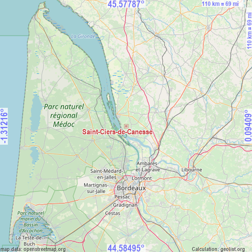
Saint-Ciers-de-Canesse GPS coordinates[2]
45° 5' 0.852" North, 0° 36' 32.544" West
| Map corner | latitude | longitude |
|---|---|---|
| Upper-left | 45.57787°, | -1.31216° |
| Center: | 45.08357°, | -0.60904° |
| Lower-right: | 44.58495°, | 0.09409° |
| Map W x H: | 110.4×110.4 km | = 68.6×68.6mi |
| max Lat: | 51.07786° ⇑78.7% North |
| Saint-Ciers-de-Canesse: | 45.08357° |
| min Lat: | ⇓21.3% South 41.3874° |
| min Long | Saint-Ciers-de- | max Long |
| -5.08615° | -0.60904° | 9.52242° |
| W 15.4%⇐ | ⇒84.6% E |
Elevation
Elevation of Saint-Ciers-de-Canesse is 42 m = 138 ft, and this is 151.7 m = 498 ft below average elevation for this country.
| Max E: |
2333 m = 7654 ft | 84.9% |
| Avg. | 193.7 m = 635 ft | |
| Saint-Ciers-de-Canesse | 42 m = 138 ft | |
Min E: |
-1 m = -3 ft | 15.1% |
See also: France elevation on elevation.city.
Geographical zone
Saint-Ciers-de-Canesse is located in North temperate zone (between Tropic of Cancer and the Arctic Circle). Distance of this North polar circle is 2388.4 km =1484.1 mi to North.| Distance of | km | miles | from Saint-Ciers-de-Canesse |
|---|---|---|---|
| North Pole | 4994.2 | 3103.3 | to North |
| Arctic Circle | 2388.4 | 1484.1 | to North |
| Tropic Cancer | 2406.9 | 1495.6 | to South |
| Equator | 5012.8 | 3114.8 | to South |


Nearby cities:
15 places around Saint-Ciers-de-Canesse: (largest is in red/bold)
• Bayon-sur-Gironde
4.2 km =2.6 mi,  151°
151°
• Berson
3.1 km =1.9 mi,  32°
32°
• Blaye
6.5 km =4 mi,  319°
319°
• Bourg
6.2 km =3.9 mi,  140°
140°
• Cantenac
7.1 km =4.4 mi,  209°
209°
• Cars
5.1 km =3.2 mi,  350°
350°
• Gauriac
2 km =1.2 mi,  190°
190°
• Labarde
7.9 km =4.9 mi,  197°
197°
• Lansac
5.8 km =3.6 mi,  114°
114°
• Margaux
7.3 km =4.5 mi,  228°
228°
• Plassac
3.6 km =2.2 mi,  307°
307°
• Saint-Martin-Lacaussade
7.5 km =4.7 mi,  339°
339°
• Saint-Paul
7.2 km =4.5 mi,  3°
3°
• Soussans
7.7 km =4.8 mi,  246°
246°
• Teuillac
4.9 km =3 mi,  78°
78°
Sources, notices
• [Note1] Compared only with cities in France existing in our database
• [Src1] Map data: © OpenStreetMap contributors (CC-BY-SA)
• [Src2] Other city data from geonames.org with taken over terms of usage.
• [Src3] Geographical zone / Annual Mean Temperature by Robert A. Rohde @ Wikipedia
