Souligné-Flacé geodata
Souligné-Flacé (Pays de la Loire) is a populated place; located in France in Europe/Paris (GMT+2) time zone. With population of 695 people, there are 11873 cities with bigger population in this country. Compared to other cities in France, 58.8% of cities are located further ↓South; 78% of cities are located further →East and 68.3% of cities have higher elevation than Souligné-Flacé. Note1
Administrative division(s):
- Level 1: Pays de la Loire
- Level 2: Sarthe
- Level 3: Arrondissement de La Flèche
- Level 4: Souligné-Flacé


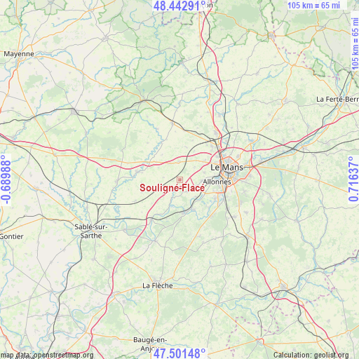
Souligné-Flacé GPS coordinates[2]
47° 58' 27.624" North, 0° 0' 47.7" East
| Map corner | latitude | longitude |
|---|---|---|
| Upper-left | 48.44291°, | -0.68988° |
| Center: | 47.97434°, | 0.01325° |
| Lower-right: | 47.50148°, | 0.71637° |
| Map W x H: | 104.7×104.7 km | = 65.1×65.1mi |
| max Lat: | 51.07786° ⇑41.2% North |
| Souligné-Flacé: | 47.97434° |
| min Lat: | ⇓58.8% South 41.3874° |
| min Long | Souligné-Flac� | max Long |
| -5.08615° | 0.01325° | 9.52242° |
| W 22%⇐ | ⇒78% E |
Elevation
Elevation of Souligné-Flacé is 82 m = 269 ft, and this is 111.7 m = 366 ft below average elevation for this country.
| Max E: |
2333 m = 7654 ft | 68.3% |
| Avg. | 193.7 m = 635 ft | |
| Souligné-Flacé | 82 m = 269 ft | |
Min E: |
-1 m = -3 ft | 31.7% |
See also: France elevation on elevation.city.
Geographical zone
Souligné-Flacé is located in North temperate zone (between Tropic of Cancer and the Arctic Circle). Distance of this North polar circle is 2066.9 km =1284.3 mi to North.| Distance of | km | miles | from Souligné-Flacé |
|---|---|---|---|
| North Pole | 4672.8 | 2903.5 | to North |
| Arctic Circle | 2066.9 | 1284.3 | to North |
| Tropic Cancer | 2728.3 | 1695.3 | to South |
| Equator | 5334.2 | 3314.5 | to South |


Nearby cities:
15 places around Souligné-Flacé: (largest is in red/bold)
• Chaufour-Notre-Dame
7.3 km =4.5 mi,  38°
38°
• Chemiré-le-Gaudin
5.5 km =3.4 mi,  203°
203°
• Coulans-sur-Gée
5.2 km =3.2 mi,  357°
357°
• Degré
9.2 km =5.7 mi,  26°
26°
• Fercé-sur-Sarthe
8.8 km =5.5 mi, 202°
• La Quinte
9.6 km =6 mi,  11°
11°
• La Suze-sur-Sarthe
9.7 km =6 mi,  174°
174°
• Louplande
5.4 km =3.4 mi,  240°
240°
• Pruillé-le-Chétif
7.3 km =4.5 mi,  72°
72°
• Roézé-sur-Sarthe
9.6 km =6 mi,  155°
155°
• Saint-Georges-du-Bois
6.5 km =4 mi,  91°
91°
• Trangé
9.3 km =5.8 mi,  50°
50°
• Vallon-sur-Gée
6.2 km =3.9 mi,  259°
259°
• Voivres-lès-le-Mans
6.6 km =4.1 mi,  138°
138°
• Étival-lès-le-Mans
5.9 km =3.7 mi,  117°
117°
Sources, notices
• [Note1] Compared only with cities in France existing in our database
• [Src1] Map data: © OpenStreetMap contributors (CC-BY-SA)
• [Src2] Other city data from geonames.org with taken over terms of usage.
• [Src3] Geographical zone / Annual Mean Temperature by Robert A. Rohde @ Wikipedia
