Roézé-sur-Sarthe geodata
Roézé-sur-Sarthe (Pays de la Loire) is a populated place; located in France in Europe/Paris (GMT+2) time zone. With population of 2,626 people, there are 3714 cities with bigger population in this country. Compared to other cities in France, 57.5% of cities are located further ↓South; 77.6% of cities are located further →East and 79.8% of cities have higher elevation than Roézé-sur-Sarthe. Note1
Administrative division(s):
- Level 1: Pays de la Loire
- Level 2: Sarthe
- Level 3: Arrondissement de La Flèche
- Level 4: Roézé-sur-Sarthe


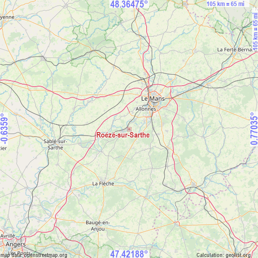
Roézé-sur-Sarthe GPS coordinates[2]
47° 53' 43.656" North, 0° 4' 2.028" East
| Map corner | latitude | longitude |
|---|---|---|
| Upper-left | 48.36475°, | -0.6359° |
| Center: | 47.89546°, | 0.06723° |
| Lower-right: | 47.42188°, | 0.77035° |
| Map W x H: | 104.8×104.8 km | = 65.1×65.1mi |
| max Lat: | 51.07786° ⇑42.5% North |
| Roézé-sur-Sarthe: | 47.89546° |
| min Lat: | ⇓57.5% South 41.3874° |
| min Long | Roézé-sur-Sar | max Long |
| -5.08615° | 0.06723° | 9.52242° |
| W 22.4%⇐ | ⇒77.6% E |
Elevation
Elevation of Roézé-sur-Sarthe is 55 m = 180 ft, and this is 138.7 m = 455 ft below average elevation for this country.
| Max E: |
2333 m = 7654 ft | 79.8% |
| Avg. | 193.7 m = 635 ft | |
| Roézé-sur-Sarthe | 55 m = 180 ft | |
Min E: |
-1 m = -3 ft | 20.2% |
See also: France elevation on elevation.city.
Geographical zone
Roézé-sur-Sarthe is located in North temperate zone (between Tropic of Cancer and the Arctic Circle). Distance of this North polar circle is 2075.7 km =1289.8 mi to North.| Distance of | km | miles | from Roézé-sur-Sarthe |
|---|---|---|---|
| North Pole | 4681.6 | 2909 | to North |
| Arctic Circle | 2075.7 | 1289.8 | to North |
| Tropic Cancer | 2719.6 | 1689.9 | to South |
| Equator | 5325.5 | 3309.1 | to South |


Nearby cities:
15 places around Roézé-sur-Sarthe: (largest is in red/bold)
• Arnage
9.6 km =6 mi,  69°
69°
• Chemiré-le-Gaudin
7.2 km =4.5 mi,  301°
301°
• Cérans-Foulletourte
7.7 km =4.8 mi,  174°
174°
• Fercé-sur-Sarthe
7.4 km =4.6 mi,  275°
275°
• Fillé
4.4 km =2.7 mi,  83°
83°
• Guécélard
5 km =3.1 mi,  113°
113°
• La Suze-sur-Sarthe
3.3 km =2.1 mi,  254°
254°
• Moncé-en-Belin
9.8 km =6.1 mi,  90°
90°
• Parigné-le-Pôlin
5.9 km =3.7 mi,  149°
149°
• Saint-Georges-du-Bois
8.9 km =5.5 mi,  16°
16°
• Saint-Jean-du-Bois
8.3 km =5.2 mi, 251°
• Souligné-Flacé
9.6 km =6 mi,  335°
335°
• Spay
7.1 km =4.4 mi,  63°
63°
• Voivres-lès-le-Mans
3.8 km =2.4 mi,  5°
5°
• Étival-lès-le-Mans
6.2 km =3.9 mi, 11°
Sources, notices
• [Note1] Compared only with cities in France existing in our database
• [Src1] Map data: © OpenStreetMap contributors (CC-BY-SA)
• [Src2] Other city data from geonames.org with taken over terms of usage.
• [Src3] Geographical zone / Annual Mean Temperature by Robert A. Rohde @ Wikipedia
