Soucieu-en-Jarrest geodata
Soucieu-en-Jarrest (Auvergne-Rhône-Alpes) is a populated place; located in France in Europe/Paris (GMT+2) time zone. With population of 3,395 people, there are 2869 cities with bigger population in this country. Compared to other cities in France, 71.3% of cities are located further ↑North; 73.8% of cities are located further ←West and 82.8% of cities have lower elevation than Soucieu-en-Jarrest. Note1
Administrative division(s):
- Level 1: Auvergne-Rhône-Alpes
- Level 2: Département du Rhône
- Level 3: Arrondissement de Lyon
- Level 4: Soucieu-en-Jarrest


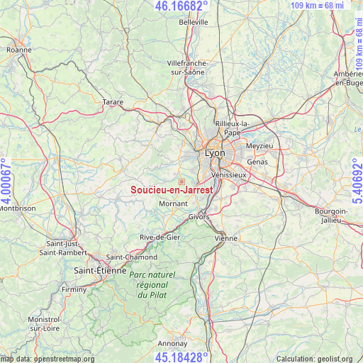
Soucieu-en-Jarrest GPS coordinates[2]
45° 40' 39.756" North, 4° 42' 13.644" East
| Map corner | latitude | longitude |
|---|---|---|
| Upper-left | 46.16682°, | 4.00067° |
| Center: | 45.67771°, | 4.70379° |
| Lower-right: | 45.18428°, | 5.40692° |
| Map W x H: | 109.2×109.2 km | = 67.9×67.9mi |
| max Lat: | 51.07786° ⇑71.3% North |
| Soucieu-en-Jarrest: | 45.67771° |
| min Lat: | ⇓28.7% South 41.3874° |
| min Long | Soucieu-en-Jarr | max Long |
| -5.08615° | 4.70379° | 9.52242° |
| W 73.8%⇐ | ⇒26.2% E |
Elevation
Elevation of Soucieu-en-Jarrest is 320 m = 1050 ft, and this is 126.3 m = 414 ft above average elevation for this country.
| Max E: |
2333 m = 7654 ft | 17.2% |
| Soucieu-en-Jarrest | 320 m 1050 ft | |
| Avg. | 193.7 m = 635 ft | |
Min E: |
-1 m = -3 ft | 82.8% |
See also: France elevation on elevation.city.
Geographical zone
Soucieu-en-Jarrest is located in North temperate zone (between Tropic of Cancer and the Arctic Circle). Distance of this North polar circle is 2322.3 km =1443 mi to North.| Distance of | km | miles | from Soucieu-en-Jarrest |
|---|---|---|---|
| North Pole | 4928.2 | 3062.2 | to North |
| Arctic Circle | 2322.3 | 1443 | to North |
| Tropic Cancer | 2473 | 1536.7 | to South |
| Equator | 5078.9 | 3155.9 | to South |


Nearby cities:
15 places around Soucieu-en-Jarrest: (largest is in red/bold)
• Brignais
3.9 km =2.4 mi,  96°
96°
• Brindas
4.9 km =3 mi,  350°
350°
• Chaponost
4.7 km =2.9 mi,  39°
39°
• Chaussan
7 km =4.3 mi,  225°
225°
• Craponne
7.7 km =4.8 mi,  11°
11°
• Messimy
3.2 km =2 mi,  314°
314°
• Montagny
6.5 km =4 mi,  148°
148°
• Mornant
7 km =4.3 mi,  200°
200°
• Orliénas
2.4 km =1.5 mi, 151°
• Rontalon
5.9 km =3.7 mi,  250°
250°
• Saint-Genis-Laval
7.2 km =4.5 mi,  74°
74°
• Taluyers
4.5 km =2.8 mi,  161°
161°
• Thurins
4.9 km =3 mi,  275°
275°
• Vaugneray
7.6 km =4.7 mi,  331°
331°
• Vourles
5.8 km =3.6 mi,  111°
111°
Sources, notices
• [Note1] Compared only with cities in France existing in our database
• [Src1] Map data: © OpenStreetMap contributors (CC-BY-SA)
• [Src2] Other city data from geonames.org with taken over terms of usage.
• [Src3] Geographical zone / Annual Mean Temperature by Robert A. Rohde @ Wikipedia
