Chaponost geodata
Chaponost (Auvergne-Rhône-Alpes) is a populated place; located in France in Europe/Paris (GMT+2) time zone. With population of 8,286 people, there are 1170 cities with bigger population in this country. Compared to other cities in France, 70.7% of cities are located further ↑North; 74.2% of cities are located further ←West and 82.6% of cities have lower elevation than Chaponost. Note1
Administrative division(s):
- Level 1: Auvergne-Rhône-Alpes
- Level 2: Département du Rhône
- Level 3: Arrondissement de Lyon
- Level 4: Chaponost


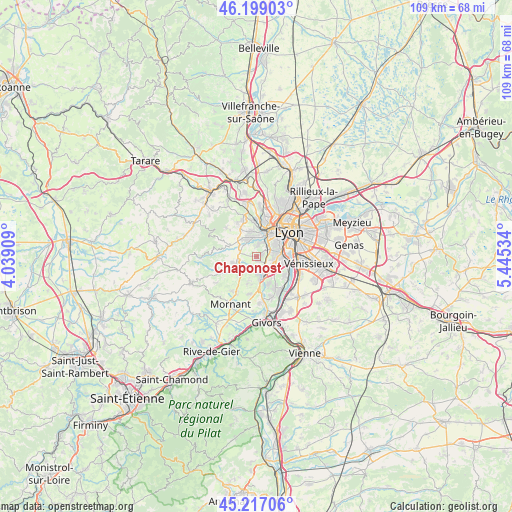
Chaponost GPS coordinates[2]
45° 42' 36.72" North, 4° 44' 31.956" East
| Map corner | latitude | longitude |
|---|---|---|
| Upper-left | 46.19903°, | 4.03909° |
| Center: | 45.7102°, | 4.74221° |
| Lower-right: | 45.21706°, | 5.44534° |
| Map W x H: | 109.2×109.2 km | = 67.9×67.9mi |
| max Lat: | 51.07786° ⇑70.7% North |
| Chaponost: | 45.7102° |
| min Lat: | ⇓29.3% South 41.3874° |
| min Long | Chaponost | max Long |
| -5.08615° | 4.74221° | 9.52242° |
| W 74.2%⇐ | ⇒25.8% E |
Elevation
Elevation of Chaponost is 317 m = 1040 ft, and this is 123.3 m = 405 ft above average elevation for this country.
| Max E: |
2333 m = 7654 ft | 17.4% |
| Chaponost | 317 m 1040 ft | |
| Avg. | 193.7 m = 635 ft | |
Min E: |
-1 m = -3 ft | 82.6% |
See also: France elevation on elevation.city.
Geographical zone
Chaponost is located in North temperate zone (between Tropic of Cancer and the Arctic Circle). Distance of this North polar circle is 2318.7 km =1440.8 mi to North.| Distance of | km | miles | from Chaponost |
|---|---|---|---|
| North Pole | 4924.6 | 3060 | to North |
| Arctic Circle | 2318.7 | 1440.8 | to North |
| Tropic Cancer | 2476.6 | 1538.9 | to South |
| Equator | 5082.5 | 3158.1 | to South |


Nearby cities:
15 places around Chaponost: (largest is in red/bold)
• Brignais
4.1 km =2.5 mi,  167°
167°
• Brindas
4 km =2.5 mi,  287°
287°
• Craponne
4.2 km =2.6 mi,  339°
339°
• Francheville
3.3 km =2.1 mi,  29°
29°
• Grézieu-la-Varenne
5.8 km =3.6 mi,  315°
315°
• La Mulatière
5.8 km =3.6 mi,  69°
69°
• Messimy
5.4 km =3.4 mi,  255°
255°
• Orliénas
6 km =3.7 mi,  198°
198°
• Oullins
5.1 km =3.2 mi,  85°
85°
• Saint-Genis-Laval
4.3 km =2.7 mi,  112°
112°
• Saint-Genis-les-Ollières
5.4 km =3.4 mi,  346°
346°
• Sainte-Foy-lès-Lyon
5.4 km =3.4 mi,  60°
60°
• Soucieu-en-Jarrest
4.7 km =2.9 mi,  219°
219°
• Tassin-la-Demi-Lune
6.1 km =3.8 mi,  35°
35°
• Vourles
6.2 km =3.9 mi,  157°
157°
Sources, notices
• [Note1] Compared only with cities in France existing in our database
• [Src1] Map data: © OpenStreetMap contributors (CC-BY-SA)
• [Src2] Other city data from geonames.org with taken over terms of usage.
• [Src3] Geographical zone / Annual Mean Temperature by Robert A. Rohde @ Wikipedia
