Craponne geodata
Craponne (Auvergne-Rhône-Alpes) is a populated place; located in France in Europe/Paris (GMT+2) time zone. With population of 8,460 people, there are 1147 cities with bigger population in this country. Compared to other cities in France, 70.1% of cities are located further ↑North; 74% of cities are located further ←West and 78.4% of cities have lower elevation than Craponne. Note1
Administrative division(s):
- Level 1: Auvergne-Rhône-Alpes
- Level 2: Département du Rhône
- Level 3: Arrondissement de Lyon
- Level 4: Craponne


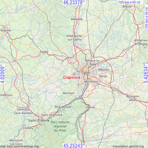
Craponne GPS coordinates[2]
45° 44' 42.936" North, 4° 43' 23.592" East
| Map corner | latitude | longitude |
|---|---|---|
| Upper-left | 46.23378°, | 4.02009° |
| Center: | 45.74526°, | 4.72322° |
| Lower-right: | 45.25243°, | 5.42634° |
| Map W x H: | 109.1×109.1 km | = 67.8×67.8mi |
| max Lat: | 51.07786° ⇑70.1% North |
| Craponne: | 45.74526° |
| min Lat: | ⇓29.9% South 41.3874° |
| min Long | Craponne | max Long |
| -5.08615° | 4.72322° | 9.52242° |
| W 74%⇐ | ⇒26% E |
Elevation
Elevation of Craponne is 275 m = 902 ft, and this is 81.3 m = 267 ft above average elevation for this country.
| Max E: |
2333 m = 7654 ft | 21.6% |
| Craponne | 275 m 902 ft | |
| Avg. | 193.7 m = 635 ft | |
Min E: |
-1 m = -3 ft | 78.4% |
See also: France elevation on elevation.city.
Geographical zone
Craponne is located in North temperate zone (between Tropic of Cancer and the Arctic Circle). Distance of this North polar circle is 2314.8 km =1438.3 mi to North.| Distance of | km | miles | from Craponne |
|---|---|---|---|
| North Pole | 4920.7 | 3057.6 | to North |
| Arctic Circle | 2314.8 | 1438.3 | to North |
| Tropic Cancer | 2480.5 | 1541.3 | to South |
| Equator | 5086.4 | 3160.5 | to South |


Nearby cities:
15 places around Craponne: (largest is in red/bold)
• Brindas
3.5 km =2.2 mi,  220°
220°
• Chaponost
4.2 km =2.6 mi,  159°
159°
• Charbonnières-les-Bains
4.3 km =2.7 mi,  24°
24°
• Dardilly
7.1 km =4.4 mi, 19°
• Francheville
3.3 km =2.1 mi,  107°
107°
• Grézieu-la-Varenne
2.6 km =1.6 mi,  275°
275°
• La Mulatière
7.2 km =4.5 mi, 105°
• Messimy
6.5 km =4 mi, 215°
• Pollionnay
5.3 km =3.3 mi,  294°
294°
• Saint-Genis-les-Ollières
1.3 km =0.8 mi,  10°
10°
• Sainte-Consorce
4.3 km =2.7 mi,  323°
323°
• Sainte-Foy-lès-Lyon
6.3 km =3.9 mi,  101°
101°
• Tassin-la-Demi-Lune
5.2 km =3.2 mi,  77°
77°
• Vaugneray
5.2 km =3.2 mi,  261°
261°
• Écully
5.3 km =3.3 mi,  52°
52°
Sources, notices
• [Note1] Compared only with cities in France existing in our database
• [Src1] Map data: © OpenStreetMap contributors (CC-BY-SA)
• [Src2] Other city data from geonames.org with taken over terms of usage.
• [Src3] Geographical zone / Annual Mean Temperature by Robert A. Rohde @ Wikipedia
