Lodève geodata
Lodève (Occitanie) is a seat of a third-order administrative division; located in France in Europe/Paris (GMT+2) time zone. With population of 7,515 people, there are 1298 cities with bigger population in this country. Compared to other cities in France, 90% of cities are located further ↑North; 62.3% of cities are located further ←West and 78.3% of cities have lower elevation than Lodève. Note1
Administrative division(s):
- Level 1: Occitanie
- Level 2: Département de l'Hérault
- Level 3: Arrondissement de Lodève
- Level 4: Lodève


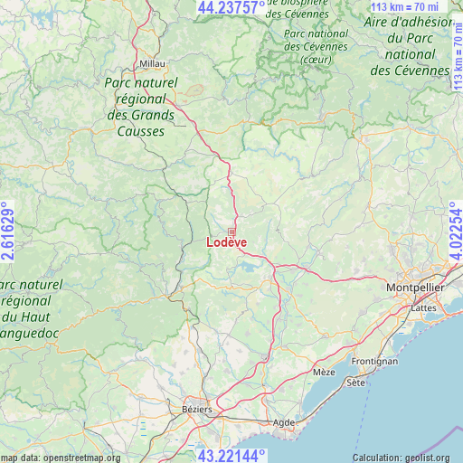
Lodève GPS coordinates[2]
43° 43' 53.976" North, 3° 19' 9.876" East
| Map corner | latitude | longitude |
|---|---|---|
| Upper-left | 44.23757°, | 2.61629° |
| Center: | 43.73166°, | 3.31941° |
| Lower-right: | 43.22144°, | 4.02254° |
| Map W x H: | 113×113 km | = 70.2×70.2mi |
| max Lat: | 51.07786° ⇑90% North |
| Lodève: | 43.73166° |
| min Lat: | ⇓10% South 41.3874° |
| min Long | Lodève | max Long |
| -5.08615° | 3.31941° | 9.52242° |
| W 62.3%⇐ | ⇒37.7% E |
Elevation
Elevation of Lodève is 274 m = 899 ft, and this is 80.3 m = 263 ft above average elevation for this country.
| Max E: |
2333 m = 7654 ft | 21.7% |
| Lodève | 274 m 899 ft | |
| Avg. | 193.7 m = 635 ft | |
Min E: |
-1 m = -3 ft | 78.3% |
See also: France elevation on elevation.city.
Geographical zone
Lodève is located in North temperate zone (between Tropic of Cancer and the Arctic Circle). Distance of this Northern Tropic circle is 2256.6 km =1402.2 mi to South.| Distance of | km | miles | from Lodève |
|---|---|---|---|
| North Pole | 5144.6 | 3196.7 | to North |
| Arctic Circle | 2538.7 | 1577.5 | to North |
| Tropic Cancer | 2256.6 | 1402.2 | to South |
| Equator | 4862.5 | 3021.4 | to South |


Nearby cities:
15 places around Lodève: (largest is in red/bold)
• Bédarieux
18.4 km =11.4 mi,  225°
225°
• Gignac
20.6 km =12.8 mi,  115°
115°
• Graissessac
19 km =11.8 mi,  251°
251°
• La Tour-sur-Orb
16.2 km =10.1 mi,  236°
236°
• Le Bosc
5.9 km =3.7 mi, 115°
• Le Bousquet-d’Orb
13 km =8.1 mi, 250°
• Lunas
10.6 km =6.6 mi,  255°
255°
• Montpeyroux
15.5 km =9.6 mi,  104°
104°
• Nébian
16.6 km =10.3 mi,  147°
147°
• Pouzols
20.1 km =12.5 mi,  129°
129°
• Péret
18.5 km =11.5 mi,  160°
160°
• Saint-André-de-Sangonis
17.4 km =10.8 mi, 122°
• Saint-Félix-de-Lodez
13.7 km =8.5 mi, 124°
• Saint-Jean-de-Fos
19 km =11.8 mi, 100°
• Soubès
4.6 km =2.9 mi,  28°
28°
Sources, notices
• [Note1] Compared only with cities in France existing in our database
• [Src1] Map data: © OpenStreetMap contributors (CC-BY-SA)
• [Src2] Other city data from geonames.org with taken over terms of usage.
• [Src3] Geographical zone / Annual Mean Temperature by Robert A. Rohde @ Wikipedia
