Péret geodata
Péret (Occitanie) is a populated place; located in France in Europe/Paris (GMT+2) time zone. With population of 635 people, there are 12740 cities with bigger population in this country. Compared to other cities in France, 92.1% of cities are located further ↑North; 63.2% of cities are located further ←West and 53.6% of cities have lower elevation than Péret. Note1
Administrative division(s):
- Level 1: Occitanie
- Level 2: Département de l'Hérault
- Level 3: Arrondissement de Lodève
- Level 4: Péret


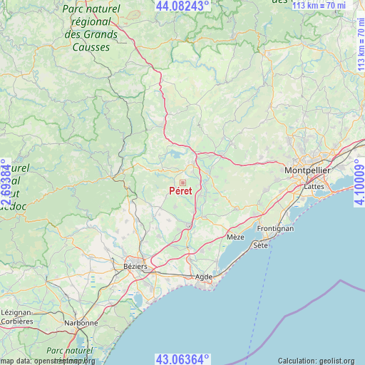
Péret GPS coordinates[2]
43° 34' 30.684" North, 3° 23' 49.056" East
| Map corner | latitude | longitude |
|---|---|---|
| Upper-left | 44.08243°, | 2.69384° |
| Center: | 43.57519°, | 3.39696° |
| Lower-right: | 43.06364°, | 4.10009° |
| Map W x H: | 113.3×113.3 km | = 70.4×70.4mi |
| max Lat: | 51.07786° ⇑92.1% North |
| Péret: | 43.57519° |
| min Lat: | ⇓7.9% South 41.3874° |
| min Long | Péret | max Long |
| -5.08615° | 3.39696° | 9.52242° |
| W 63.2%⇐ | ⇒36.8% E |
Elevation
Elevation of Péret is 145 m = 476 ft, and this is 48.7 m = 160 ft below average elevation for this country.
| Max E: |
2333 m = 7654 ft | 46.4% |
| Avg. | 193.7 m = 635 ft | |
| Péret | 145 m = 476 ft | |
Min E: |
-1 m = -3 ft | 53.6% |
See also: France elevation on elevation.city.
Geographical zone
Péret is located in North temperate zone (between Tropic of Cancer and the Arctic Circle). Distance of this Northern Tropic circle is 2239.2 km =1391.4 mi to South.| Distance of | km | miles | from Péret |
|---|---|---|---|
| North Pole | 5162 | 3207.5 | to North |
| Arctic Circle | 2556.1 | 1588.3 | to North |
| Tropic Cancer | 2239.2 | 1391.4 | to South |
| Equator | 4845.1 | 3010.6 | to South |


Nearby cities:
15 places around Péret: (largest is in red/bold)
• Adissan
5.1 km =3.2 mi,  152°
152°
• Aspiran
4.4 km =2.7 mi,  103°
103°
• Caux
8 km =5 mi,  197°
197°
• Fontès
4.2 km =2.6 mi, 199°
• Le Pouget
10.4 km =6.5 mi,  79°
79°
• Lézignan-la-Cèbe
9.6 km =6 mi,  160°
160°
• Neffiès
6.9 km =4.3 mi,  227°
227°
• Nizas
6.9 km =4.3 mi,  172°
172°
• Nébian
4.5 km =2.8 mi,  38°
38°
• Paulhan
6.3 km =3.9 mi,  129°
129°
• Plaissan
10.6 km =6.6 mi, 100°
• Pouzols
10.5 km =6.5 mi,  63°
63°
• Roujan
10.5 km =6.5 mi,  221°
221°
• Saint-Félix-de-Lodez
10.9 km =6.8 mi,  27°
27°
• Saint-Pargoire
11.1 km =6.9 mi,  118°
118°
Sources, notices
• [Note1] Compared only with cities in France existing in our database
• [Src1] Map data: © OpenStreetMap contributors (CC-BY-SA)
• [Src2] Other city data from geonames.org with taken over terms of usage.
• [Src3] Geographical zone / Annual Mean Temperature by Robert A. Rohde @ Wikipedia
