Sorel-Moussel geodata
Sorel-Moussel (Centre) is a populated place; located in France in Europe/Paris (GMT+2) time zone. With population of 1,526 people, there are 6101 cities with bigger population in this country. Compared to other cities in France, 76.2% of cities are located further ↓South; 64.8% of cities are located further →East and 67.8% of cities have higher elevation than Sorel-Moussel. Note1
Administrative division(s):
- Level 1: Centre
- Level 2: Département d'Eure-et-Loir
- Level 3: Arrondissement de Dreux
- Level 4: Sorel-Moussel


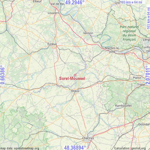
Sorel-Moussel GPS coordinates[2]
48° 50' 2.076" North, 1° 22' 1.164" East
| Map corner | latitude | longitude |
|---|---|---|
| Upper-left | 49.2946°, | 0.66386° |
| Center: | 48.83391°, | 1.36699° |
| Lower-right: | 48.36894°, | 2.07011° |
| Map W x H: | 102.9×102.9 km | = 63.9×63.9mi |
| max Lat: | 51.07786° ⇑23.8% North |
| Sorel-Moussel: | 48.83391° |
| min Lat: | ⇓76.2% South 41.3874° |
| min Long | Sorel-Moussel | max Long |
| -5.08615° | 1.36699° | 9.52242° |
| W 35.2%⇐ | ⇒64.8% E |
Elevation
Elevation of Sorel-Moussel is 83 m = 272 ft, and this is 110.7 m = 363 ft below average elevation for this country.
| Max E: |
2333 m = 7654 ft | 67.8% |
| Avg. | 193.7 m = 635 ft | |
| Sorel-Moussel | 83 m = 272 ft | |
Min E: |
-1 m = -3 ft | 32.2% |
See also: France elevation on elevation.city.
Geographical zone
Sorel-Moussel is located in North temperate zone (between Tropic of Cancer and the Arctic Circle). Distance of this North polar circle is 1971.4 km =1225 mi to North.| Distance of | km | miles | from Sorel-Moussel |
|---|---|---|---|
| North Pole | 4577.2 | 2844.1 | to North |
| Arctic Circle | 1971.4 | 1225 | to North |
| Tropic Cancer | 2823.9 | 1754.7 | to South |
| Equator | 5429.8 | 3373.9 | to South |


Nearby cities:
15 places around Sorel-Moussel: (largest is in red/bold)
• Abondant
7.6 km =4.7 mi,  134°
134°
• Anet
5.9 km =3.7 mi,  64°
64°
• Bois-le-Roi
3.6 km =2.2 mi,  331°
331°
• Courdemanche
6.4 km =4 mi,  252°
252°
• Croth
1.6 km =1 mi,  33°
33°
• La Couture-Boussey
7.4 km =4.6 mi,  21°
21°
• Marcilly-sur-Eure
1.7 km =1.1 mi,  237°
237°
• Montreuil
6.3 km =3.9 mi,  178°
178°
• Mouettes
7 km =4.3 mi,  356°
356°
• Mousseaux-Neuville
8.4 km =5.2 mi,  350°
350°
• Muzy
6.8 km =4.2 mi,  191°
191°
• Oulins
8.3 km =5.2 mi,  65°
65°
• Saint-Georges-Motel
4.5 km =2.8 mi, 180°
• Saussay
3.9 km =2.4 mi,  51°
51°
• Ézy-sur-Eure
5.1 km =3.2 mi,  44°
44°
Sources, notices
• [Note1] Compared only with cities in France existing in our database
• [Src1] Map data: © OpenStreetMap contributors (CC-BY-SA)
• [Src2] Other city data from geonames.org with taken over terms of usage.
• [Src3] Geographical zone / Annual Mean Temperature by Robert A. Rohde @ Wikipedia
