Saint-Georges-Motel geodata
Saint-Georges-Motel (Normandy) is a populated place; located in France in Europe/Paris (GMT+2) time zone. With population of 998 people, there are 8844 cities with bigger population in this country. Compared to other cities in France, 75.4% of cities are located further ↓South; 64.8% of cities are located further →East and 71.9% of cities have higher elevation than Saint-Georges-Motel. Note1
Administrative division(s):
- Level 1: Normandy
- Level 2: Département de l'Eure
- Level 3: Arrondissement d’Évreux
- Level 4: Saint-Georges-Motel


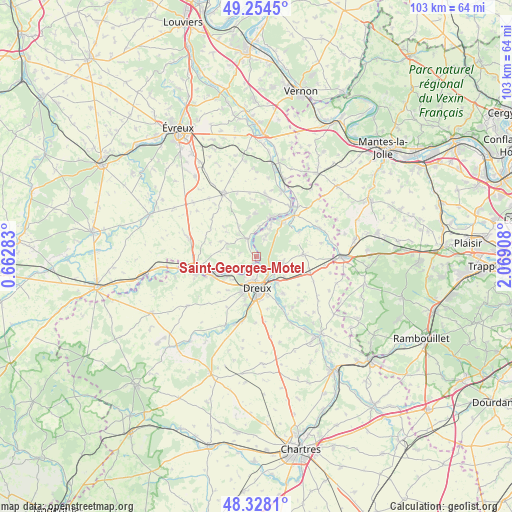
Saint-Georges-Motel GPS coordinates[2]
48° 47' 36.384" North, 1° 21' 57.42" East
| Map corner | latitude | longitude |
|---|---|---|
| Upper-left | 49.2545°, | 0.66283° |
| Center: | 48.79344°, | 1.36595° |
| Lower-right: | 48.3281°, | 2.06908° |
| Map W x H: | 103×103 km | = 64×64mi |
| max Lat: | 51.07786° ⇑24.6% North |
| Saint-Georges-Motel: | 48.79344° |
| min Lat: | ⇓75.4% South 41.3874° |
| min Long | Saint-Georges-M | max Long |
| -5.08615° | 1.36595° | 9.52242° |
| W 35.2%⇐ | ⇒64.8% E |
Elevation
Elevation of Saint-Georges-Motel is 74 m = 243 ft, and this is 119.7 m = 393 ft below average elevation for this country.
| Max E: |
2333 m = 7654 ft | 71.9% |
| Avg. | 193.7 m = 635 ft | |
| Saint-Georges-Motel | 74 m = 243 ft | |
Min E: |
-1 m = -3 ft | 28.1% |
See also: France elevation on elevation.city.
Geographical zone
Saint-Georges-Motel is located in North temperate zone (between Tropic of Cancer and the Arctic Circle). Distance of this North polar circle is 1975.9 km =1227.8 mi to North.| Distance of | km | miles | from Saint-Georges-Motel |
|---|---|---|---|
| North Pole | 4581.7 | 2846.9 | to North |
| Arctic Circle | 1975.9 | 1227.8 | to North |
| Tropic Cancer | 2819.4 | 1751.9 | to South |
| Equator | 5425.3 | 3371.1 | to South |


Nearby cities:
15 places around Saint-Georges-Motel: (largest is in red/bold)
• Abondant
5.5 km =3.4 mi,  98°
98°
• Bois-le-Roi
7.8 km =4.8 mi,  347°
347°
• Cherisy
6.9 km =4.3 mi,  134°
134°
• Courdemanche
6.6 km =4.1 mi,  293°
293°
• Croth
5.9 km =3.7 mi,  9°
9°
• Dreux
6.3 km =3.9 mi,  180°
180°
• Marcilly-sur-Eure
3.8 km =2.4 mi,  339°
339°
• Mesnil-sur-l’Estrée
5.4 km =3.4 mi,  241°
241°
• Montreuil
1.8 km =1.1 mi,  171°
171°
• Muzy
2.5 km =1.6 mi,  211°
211°
• Saint-Germain-sur-Avre
7.9 km =4.9 mi,  246°
246°
• Sainte-Gemme-Moronval
7.1 km =4.4 mi,  149°
149°
• Saussay
7.6 km =4.7 mi,  24°
24°
• Sorel-Moussel
4.5 km =2.8 mi,  0°
0°
• Vert-en-Drouais
6.4 km =4 mi,  234°
234°
Sources, notices
• [Note1] Compared only with cities in France existing in our database
• [Src1] Map data: © OpenStreetMap contributors (CC-BY-SA)
• [Src2] Other city data from geonames.org with taken over terms of usage.
• [Src3] Geographical zone / Annual Mean Temperature by Robert A. Rohde @ Wikipedia
