Ézy-sur-Eure geodata
Ézy-sur-Eure (Normandy) is a populated place; located in France in Europe/Paris (GMT+2) time zone. With population of 3,248 people, there are 3006 cities with bigger population in this country. Compared to other cities in France, 77% of cities are located further ↓South; 64.1% of cities are located further →East and 76.2% of cities have higher elevation than Ézy-sur-Eure. Note1
Administrative division(s):
- Level 1: Normandy
- Level 2: Département de l'Eure
- Level 3: Arrondissement d’Évreux
- Level 4: Ézy-sur-Eure


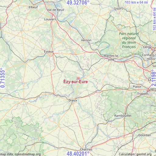
Ézy-sur-Eure GPS coordinates[2]
48° 52' 0.012" North, 1° 25' 0.012" East
| Map corner | latitude | longitude |
|---|---|---|
| Upper-left | 49.32706°, | 0.71355° |
| Center: | 48.86667°, | 1.41667° |
| Lower-right: | 48.40201°, | 2.1198° |
| Map W x H: | 102.9×102.9 km | = 63.9×63.9mi |
| max Lat: | 51.07786° ⇑23% North |
| Ézy-sur-Eure: | 48.86667° |
| min Lat: | ⇓77% South 41.3874° |
| min Long | Ézy-sur-Eure | max Long |
| -5.08615° | 1.41667° | 9.52242° |
| W 35.9%⇐ | ⇒64.1% E |
Elevation
Elevation of Ézy-sur-Eure is 64 m = 210 ft, and this is 129.7 m = 426 ft below average elevation for this country.
| Max E: |
2333 m = 7654 ft | 76.2% |
| Avg. | 193.7 m = 635 ft | |
| Ézy-sur-Eure | 64 m = 210 ft | |
Min E: |
-1 m = -3 ft | 23.8% |
See also: France elevation on elevation.city.
Geographical zone
Ézy-sur-Eure is located in North temperate zone (between Tropic of Cancer and the Arctic Circle). Distance of this North polar circle is 1967.7 km =1222.7 mi to North.| Distance of | km | miles | from Ézy-sur-Eure |
|---|---|---|---|
| North Pole | 4573.6 | 2841.9 | to North |
| Arctic Circle | 1967.7 | 1222.7 | to North |
| Tropic Cancer | 2827.5 | 1756.9 | to South |
| Equator | 5433.5 | 3376.2 | to South |


Nearby cities:
15 places around Ézy-sur-Eure: (largest is in red/bold)
• Anet
2 km =1.2 mi,  123°
123°
• Bois-le-Roi
5.4 km =3.4 mi,  264°
264°
• Bueil
7.5 km =4.7 mi,  14°
14°
• Croth
3.6 km =2.2 mi,  229°
229°
• Garennes-sur-Eure
5.2 km =3.2 mi,  17°
17°
• Guainville
7.8 km =4.8 mi,  44°
44°
• Ivry-la-Bataille
3.6 km =2.2 mi,  59°
59°
• La Couture-Boussey
3.4 km =2.1 mi,  345°
345°
• Marcilly-sur-Eure
6.8 km =4.2 mi, 228°
• Mouettes
5.2 km =3.2 mi,  308°
308°
• Mousseaux-Neuville
6.9 km =4.3 mi, 312°
• Oulins
3.9 km =2.4 mi,  93°
93°
• Rouvres
5.9 km =3.7 mi, 120°
• Saussay
1.3 km =0.8 mi,  205°
205°
• Sorel-Moussel
5.1 km =3.2 mi,  224°
224°
Sources, notices
• [Note1] Compared only with cities in France existing in our database
• [Src1] Map data: © OpenStreetMap contributors (CC-BY-SA)
• [Src2] Other city data from geonames.org with taken over terms of usage.
• [Src3] Geographical zone / Annual Mean Temperature by Robert A. Rohde @ Wikipedia
