Saint-Étienne geodata
Saint-Étienne (Auvergne-Rhône-Alpes) is a seat of a second-order administrative division; located in France in Europe/Paris (GMT+2) time zone. With population of 176,280 people, there are 14 cities with bigger population in this country. Compared to other cities in France, 74.8% of cities are located further ↑North; 71.3% of cities are located further ←West and 93.7% of cities have lower elevation than Saint-Étienne. Note1
Administrative division(s):
- Level 1: Auvergne-Rhône-Alpes
- Level 2: Département de la Loire
- Level 3: Arrondissement de Saint-Étienne
- Level 4: Saint-Étienne


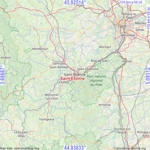
Saint-Étienne GPS coordinates[2]
45° 26' 2.004" North, 4° 23' 24" East
| Map corner | latitude | longitude |
|---|---|---|
| Upper-left | 45.92514°, | 3.68687° |
| Center: | 45.43389°, | 4.39° |
| Lower-right: | 44.93833°, | 5.09312° |
| Map W x H: | 109.7×109.7 km | = 68.2×68.2mi |
| max Lat: | 51.07786° ⇑74.8% North |
| Saint-Étienne: | 45.43389° |
| min Lat: | ⇓25.2% South 41.3874° |
| min Long | Saint-Étienne | max Long |
| -5.08615° | 4.39° | 9.52242° |
| W 71.3%⇐ | ⇒28.7% E |
Elevation
Elevation of Saint-Étienne is 529 m = 1736 ft, and this is 335.3 m = 1100 ft above average elevation for this country.
| Max E: |
2333 m = 7654 ft | 6.3% |
| Saint-Étienne | 529 m 1736 ft | |
| Avg. | 193.7 m = 635 ft | |
Min E: |
-1 m = -3 ft | 93.7% |
See also: Saint-Étienne elevation on elevation.city.
Geographical zone
Saint-Étienne is located in North temperate zone (between Tropic of Cancer and the Arctic Circle). Distance of this North polar circle is 2349.4 km =1459.8 mi to North.| Distance of | km | miles | from Saint-Étienne |
|---|---|---|---|
| North Pole | 4955.3 | 3079.1 | to North |
| Arctic Circle | 2349.4 | 1459.8 | to North |
| Tropic Cancer | 2445.9 | 1519.8 | to South |
| Equator | 5051.8 | 3139 | to South |


Nearby cities:
15 places around Saint-Étienne: (largest is in red/bold)
• Firminy
9.3 km =5.8 mi,  238°
238°
• La Fouillouse
9.8 km =6.1 mi,  323°
323°
• La Ricamarie
3.6 km =2.2 mi,  206°
206°
• La Talaudière
5.5 km =3.4 mi,  30°
30°
• La Tour-en-Jarez
5.5 km =3.4 mi,  0°
0°
• Le Chambon-Feugerolles
7.1 km =4.4 mi,  228°
228°
• L’Étrat
5.9 km =3.7 mi,  349°
349°
• Planfoy
7 km =4.3 mi,  144°
144°
• Roche-la-Molière
4.8 km =3 mi,  266°
266°
• Saint-Genest-Lerpt
4.1 km =2.5 mi,  285°
285°
• Saint-Jean-Bonnefonds
4.8 km =3 mi,  58°
58°
• Saint-Priest-en-Jarez
4.6 km =2.9 mi, 346°
• Saint-Romain-les-Atheux
7.6 km =4.7 mi,  187°
187°
• Sorbiers
7.5 km =4.7 mi, 32°
• Villars
4.6 km =2.9 mi, 324°
Sources, notices
• [Note1] Compared only with cities in France existing in our database
• [Src1] Map data: © OpenStreetMap contributors (CC-BY-SA)
• [Src2] Other city data from geonames.org with taken over terms of usage.
• [Src3] Geographical zone / Annual Mean Temperature by Robert A. Rohde @ Wikipedia
