Sommevoire geodata
Sommevoire (Grand Est) is a populated place; located in France in Europe/Paris (GMT+2) time zone. With population of 762 people, there are 11040 cities with bigger population in this country. Compared to other cities in France, 66.6% of cities are located further ↓South; 75.7% of cities are located further ←West and 55.9% of cities have lower elevation than Sommevoire. Note1
Administrative division(s):
- Level 1: Grand Est
- Level 2: Haute-Marne
- Level 3: Arrondissement de Saint-Dizier
- Level 4: Sommevoire


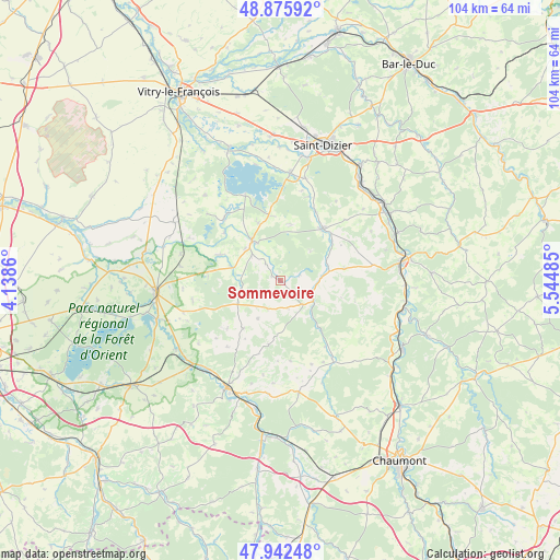
Sommevoire GPS coordinates[2]
48° 24' 40.824" North, 4° 50' 30.192" East
| Map corner | latitude | longitude |
|---|---|---|
| Upper-left | 48.87592°, | 4.1386° |
| Center: | 48.41134°, | 4.84172° |
| Lower-right: | 47.94248°, | 5.54485° |
| Map W x H: | 103.8×103.8 km | = 64.5×64.5mi |
| max Lat: | 51.07786° ⇑33.4% North |
| Sommevoire: | 48.41134° |
| min Lat: | ⇓66.6% South 41.3874° |
| min Long | Sommevoire | max Long |
| -5.08615° | 4.84172° | 9.52242° |
| W 75.7%⇐ | ⇒24.3% E |
Elevation
Elevation of Sommevoire is 153 m = 502 ft, and this is 40.7 m = 134 ft below average elevation for this country.
| Max E: |
2333 m = 7654 ft | 44.1% |
| Avg. | 193.7 m = 635 ft | |
| Sommevoire | 153 m = 502 ft | |
Min E: |
-1 m = -3 ft | 55.9% |
See also: France elevation on elevation.city.
Geographical zone
Sommevoire is located in North temperate zone (between Tropic of Cancer and the Arctic Circle). Distance of this North polar circle is 2018.3 km =1254.1 mi to North.| Distance of | km | miles | from Sommevoire |
|---|---|---|---|
| North Pole | 4624.2 | 2873.3 | to North |
| Arctic Circle | 2018.3 | 1254.1 | to North |
| Tropic Cancer | 2776.9 | 1725.5 | to South |
| Equator | 5382.8 | 3344.7 | to South |


Nearby cities:
15 places around Sommevoire: (largest is in red/bold)
• Bar-sur-Aube
22.2 km =13.8 mi,  206°
206°
• Brienne-le-Château
23.4 km =14.5 mi,  265°
265°
• Brousseval
12.7 km =7.9 mi,  46°
46°
• Ceffonds
8.8 km =5.5 mi,  319°
319°
• Chavanges
22.4 km =13.9 mi,  298°
298°
• Colombey-les-Deux-Églises
21.9 km =13.6 mi,  171°
171°
• Humbécourt
19.6 km =12.2 mi,  13°
13°
• Joinville
22.4 km =13.9 mi,  80°
80°
• Laneuville-à-Rémy
7.6 km =4.7 mi,  23°
23°
• Louvemont
16.5 km =10.3 mi, 18°
• Montier-en-Der
9.1 km =5.7 mi, 324°
• Rachecourt-sur-Marne
23 km =14.3 mi,  56°
56°
• Valcourt
23.4 km =14.5 mi, 11°
• Vecqueville
22.7 km =14.1 mi, 76°
• Wassy
12.4 km =7.7 mi,  39°
39°
Sources, notices
• [Note1] Compared only with cities in France existing in our database
• [Src1] Map data: © OpenStreetMap contributors (CC-BY-SA)
• [Src2] Other city data from geonames.org with taken over terms of usage.
• [Src3] Geographical zone / Annual Mean Temperature by Robert A. Rohde @ Wikipedia
