Chavanges geodata
Chavanges (Grand Est) is a populated place; located in France in Europe/Paris (GMT+2) time zone. With population of 703 people, there are 11764 cities with bigger population in this country. Compared to other cities in France, 68.5% of cities are located further ↓South; 72.6% of cities are located further ←West and 51.7% of cities have higher elevation than Chavanges. Note1
Administrative division(s):
- Level 1: Grand Est
- Level 2: Département de l'Aube
- Level 3: Arrondissement de Bar-sur-Aube
- Level 4: Chavanges


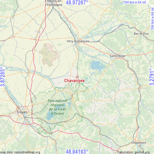
Chavanges GPS coordinates[2]
48° 30' 32.364" North, 4° 34' 33.528" East
| Map corner | latitude | longitude |
|---|---|---|
| Upper-left | 48.97267°, | 3.87285° |
| Center: | 48.50899°, | 4.57598° |
| Lower-right: | 48.04103°, | 5.2791° |
| Map W x H: | 103.6×103.6 km | = 64.4×64.4mi |
| max Lat: | 51.07786° ⇑31.5% North |
| Chavanges: | 48.50899° |
| min Lat: | ⇓68.5% South 41.3874° |
| min Long | Chavanges | max Long |
| -5.08615° | 4.57598° | 9.52242° |
| W 72.6%⇐ | ⇒27.4% E |
Elevation
Elevation of Chavanges is 126 m = 413 ft, and this is 67.7 m = 222 ft below average elevation for this country.
| Max E: |
2333 m = 7654 ft | 51.7% |
| Avg. | 193.7 m = 635 ft | |
| Chavanges | 126 m = 413 ft | |
Min E: |
-1 m = -3 ft | 48.3% |
See also: France elevation on elevation.city.
Geographical zone
Chavanges is located in North temperate zone (between Tropic of Cancer and the Arctic Circle). Distance of this North polar circle is 2007.5 km =1247.4 mi to North.| Distance of | km | miles | from Chavanges |
|---|---|---|---|
| North Pole | 4613.4 | 2866.6 | to North |
| Arctic Circle | 2007.5 | 1247.4 | to North |
| Tropic Cancer | 2787.8 | 1732.3 | to South |
| Equator | 5393.7 | 3351.5 | to South |


Nearby cities:
15 places around Chavanges: (largest is in red/bold)
• Blacy
24.1 km =15 mi,  356°
356°
• Brienne-le-Château
13.4 km =8.3 mi,  195°
195°
• Brévonnes
21.2 km =13.2 mi,  217°
217°
• Ceffonds
14.5 km =9 mi,  106°
106°
• Dienville
18 km =11.2 mi,  190°
190°
• Frignicourt
21.2 km =13.2 mi,  3°
3°
• Laneuville-à-Rémy
23 km =14.3 mi,  99°
99°
• Marolles
23.4 km =14.5 mi,  9°
9°
• Montier-en-Der
14.8 km =9.2 mi, 103°
• Perthes
24.5 km =15.2 mi,  48°
48°
• Piney
24.1 km =15 mi,  227°
227°
• Saint-Remy-en-Bouzemont-Saint-Genest-et-Isson
14.9 km =9.3 mi,  21°
21°
• Sommevoire
22.4 km =13.9 mi,  118°
118°
• Thiéblemont-Farémont
23.1 km =14.4 mi,  29°
29°
• Vitry-le-François
24 km =14.9 mi, 1°
Sources, notices
• [Note1] Compared only with cities in France existing in our database
• [Src1] Map data: © OpenStreetMap contributors (CC-BY-SA)
• [Src2] Other city data from geonames.org with taken over terms of usage.
• [Src3] Geographical zone / Annual Mean Temperature by Robert A. Rohde @ Wikipedia
