Montier-en-Der geodata
Montier-en-Der (Grand Est) is a populated place; located in France in Europe/Paris (GMT+2) time zone. With population of 2,040 people, there are 4707 cities with bigger population in this country. Compared to other cities in France, 67.9% of cities are located further ↓South; 74.7% of cities are located further ←West and 50.9% of cities have higher elevation than Montier-en-Der. Note1
Administrative division(s):
- Level 1: Grand Est
- Level 2: Haute-Marne
- Level 3: Arrondissement de Saint-Dizier
- Level 4: La Porte du Der


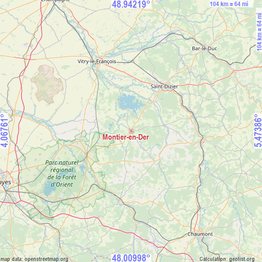
Montier-en-Der GPS coordinates[2]
48° 28' 41.628" North, 4° 46' 14.628" East
| Map corner | latitude | longitude |
|---|---|---|
| Upper-left | 48.94219°, | 4.06761° |
| Center: | 48.47823°, | 4.77073° |
| Lower-right: | 48.00998°, | 5.47386° |
| Map W x H: | 103.7×103.7 km | = 64.4×64.4mi |
| max Lat: | 51.07786° ⇑32.1% North |
| Montier-en-Der: | 48.47823° |
| min Lat: | ⇓67.9% South 41.3874° |
| min Long | Montier-en-Der | max Long |
| -5.08615° | 4.77073° | 9.52242° |
| W 74.7%⇐ | ⇒25.3% E |
Elevation
Elevation of Montier-en-Der is 129 m = 423 ft, and this is 64.7 m = 212 ft below average elevation for this country.
| Max E: |
2333 m = 7654 ft | 50.9% |
| Avg. | 193.7 m = 635 ft | |
| Montier-en-Der | 129 m = 423 ft | |
Min E: |
-1 m = -3 ft | 49.1% |
See also: France elevation on elevation.city.
Geographical zone
Montier-en-Der is located in North temperate zone (between Tropic of Cancer and the Arctic Circle). Distance of this North polar circle is 2010.9 km =1249.5 mi to North.| Distance of | km | miles | from Montier-en-Der |
|---|---|---|---|
| North Pole | 4616.8 | 2868.7 | to North |
| Arctic Circle | 2010.9 | 1249.5 | to North |
| Tropic Cancer | 2784.4 | 1730.1 | to South |
| Equator | 5390.3 | 3349.4 | to South |


Nearby cities:
15 places around Montier-en-Der: (largest is in red/bold)
• Brienne-le-Château
20.4 km =12.7 mi,  242°
242°
• Brousseval
14.5 km =9 mi,  84°
84°
• Ceffonds
0.9 km =0.6 mi,  211°
211°
• Chavanges
14.8 km =9.2 mi,  283°
283°
• Eurville-Bienville
22.6 km =14 mi,  58°
58°
• Humbécourt
15.2 km =9.4 mi,  39°
39°
• Laneuville-à-Rémy
8.3 km =5.2 mi,  93°
93°
• Louvemont
13.2 km =8.2 mi,  51°
51°
• Moëslains
18.3 km =11.4 mi,  30°
30°
• Perthes
20.2 km =12.6 mi,  11°
11°
• Saint-Dizier
22.1 km =13.7 mi, 36°
• Saint-Remy-en-Bouzemont-Saint-Genest-et-Isson
19.4 km =12.1 mi,  332°
332°
• Sommevoire
9.1 km =5.7 mi,  144°
144°
• Valcourt
18.4 km =11.4 mi, 33°
• Wassy
13.2 km =8.2 mi, 80°
Sources, notices
• [Note1] Compared only with cities in France existing in our database
• [Src1] Map data: © OpenStreetMap contributors (CC-BY-SA)
• [Src2] Other city data from geonames.org with taken over terms of usage.
• [Src3] Geographical zone / Annual Mean Temperature by Robert A. Rohde @ Wikipedia
