Bar-sur-Aube geodata
Bar-sur-Aube (Grand Est) is a seat of a third-order administrative division; located in France in Europe/Paris (GMT+2) time zone. With population of 5,387 people, there are 1827 cities with bigger population in this country. Compared to other cities in France, 63.3% of cities are located further ↓South; 73.8% of cities are located further ←West and 59.6% of cities have lower elevation than Bar-sur-Aube. Note1
Administrative division(s):
- Level 1: Grand Est
- Level 2: Département de l'Aube
- Level 3: Arrondissement de Bar-sur-Aube
- Level 4: Bar-sur-Aube


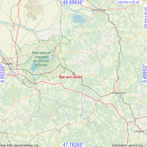
Bar-sur-Aube GPS coordinates[2]
48° 13' 59.34" North, 4° 42' 23.04" East
| Map corner | latitude | longitude |
|---|---|---|
| Upper-left | 48.69936°, | 4.00328° |
| Center: | 48.23315°, | 4.7064° |
| Lower-right: | 47.76265°, | 5.40953° |
| Map W x H: | 104.2×104.2 km | = 64.7×64.7mi |
| max Lat: | 51.07786° ⇑36.7% North |
| Bar-sur-Aube: | 48.23315° |
| min Lat: | ⇓63.3% South 41.3874° |
| min Long | Bar-sur-Aube | max Long |
| -5.08615° | 4.7064° | 9.52242° |
| W 73.8%⇐ | ⇒26.2% E |
Elevation
Elevation of Bar-sur-Aube is 168 m = 551 ft, and this is 25.7 m = 84 ft below average elevation for this country.
| Max E: |
2333 m = 7654 ft | 40.4% |
| Avg. | 193.7 m = 635 ft | |
| Bar-sur-Aube | 168 m = 551 ft | |
Min E: |
-1 m = -3 ft | 59.6% |
See also: France elevation on elevation.city.
Geographical zone
Bar-sur-Aube is located in North temperate zone (between Tropic of Cancer and the Arctic Circle). Distance of this North polar circle is 2038.2 km =1266.5 mi to North.| Distance of | km | miles | from Bar-sur-Aube |
|---|---|---|---|
| North Pole | 4644 | 2885.6 | to North |
| Arctic Circle | 2038.2 | 1266.5 | to North |
| Tropic Cancer | 2757.1 | 1713.2 | to South |
| Equator | 5363 | 3332.4 | to South |


Nearby cities:
15 places around Bar-sur-Aube: (largest is in red/bold)
• Bar-sur-Seine
27.9 km =17.3 mi,  241°
241°
• Bayel
6.6 km =4.1 mi,  126°
126°
• Brienne-le-Château
22.2 km =13.8 mi,  323°
323°
• Brévonnes
26.7 km =16.6 mi,  301°
301°
• Ceffonds
26.8 km =16.7 mi,  9°
9°
• Châteauvillain
26.9 km =16.7 mi,  144°
144°
• Colombey-les-Deux-Églises
13.2 km =8.2 mi,  97°
97°
• Dienville
18.2 km =11.3 mi, 315°
• Essoyes
23.3 km =14.5 mi,  213°
213°
• Landreville
24.8 km =15.4 mi,  224°
224°
• Lavilleneuve-au-Roi
18.2 km =11.3 mi,  116°
116°
• Montier-en-Der
27.7 km =17.2 mi, 9°
• Sommevoire
22.2 km =13.8 mi,  26°
26°
• Vendeuvre-sur-Barse
17.6 km =10.9 mi,  271°
271°
• Ville-sous-la-Ferté
14 km =8.7 mi,  153°
153°
Sources, notices
• [Note1] Compared only with cities in France existing in our database
• [Src1] Map data: © OpenStreetMap contributors (CC-BY-SA)
• [Src2] Other city data from geonames.org with taken over terms of usage.
• [Src3] Geographical zone / Annual Mean Temperature by Robert A. Rohde @ Wikipedia
