Solesmes geodata
Solesmes (Pays de la Loire) is a populated place; located in France in Europe/Paris (GMT+2) time zone. With population of 1,325 people, there are 6918 cities with bigger population in this country. Compared to other cities in France, 56.6% of cities are located further ↓South; 80.8% of cities are located further →East and 82.6% of cities have higher elevation than Solesmes. Note1
Administrative division(s):
- Level 1: Pays de la Loire
- Level 2: Sarthe
- Level 3: Arrondissement de La Flèche
- Level 4: Solesmes


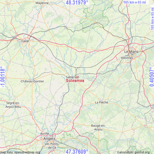
Solesmes GPS coordinates[2]
47° 51' 0.324" North, 0° 17' 53.016" West
| Map corner | latitude | longitude |
|---|---|---|
| Upper-left | 48.31979°, | -1.00118° |
| Center: | 47.85009°, | -0.29806° |
| Lower-right: | 47.37609°, | 0.40507° |
| Map W x H: | 104.9×104.9 km | = 65.2×65.2mi |
| max Lat: | 51.07786° ⇑43.4% North |
| Solesmes: | 47.85009° |
| min Lat: | ⇓56.6% South 41.3874° |
| min Long | Solesmes | max Long |
| -5.08615° | -0.29806° | 9.52242° |
| W 19.2%⇐ | ⇒80.8% E |
Elevation
Elevation of Solesmes is 48 m = 157 ft, and this is 145.7 m = 478 ft below average elevation for this country.
| Max E: |
2333 m = 7654 ft | 82.6% |
| Avg. | 193.7 m = 635 ft | |
| Solesmes | 48 m = 157 ft | |
Min E: |
-1 m = -3 ft | 17.4% |
See also: France elevation on elevation.city.
Geographical zone
Solesmes is located in North temperate zone (between Tropic of Cancer and the Arctic Circle). Distance of this North polar circle is 2080.7 km =1292.9 mi to North.| Distance of | km | miles | from Solesmes |
|---|---|---|---|
| North Pole | 4686.6 | 2912.1 | to North |
| Arctic Circle | 2080.7 | 1292.9 | to North |
| Tropic Cancer | 2714.5 | 1686.7 | to South |
| Equator | 5320.4 | 3305.9 | to South |


Nearby cities:
15 places around Solesmes: (largest is in red/bold)
• Auvers-le-Hamon
7.1 km =4.4 mi,  325°
325°
• Avoise
7 km =4.3 mi,  74°
74°
• Ballée
12.9 km =8 mi,  315°
315°
• Bouessay
7.8 km =4.8 mi,  291°
291°
• Bouère
13.4 km =8.3 mi,  276°
276°
• Chantenay-Villedieu
12.9 km =8 mi,  52°
52°
• Courtillers
5.5 km =3.4 mi,  183°
183°
• Juigné-sur-Sarthe
1.9 km =1.2 mi,  28°
28°
• Louailles
7.3 km =4.5 mi,  151°
151°
• Parcé-sur-Sarthe
7.3 km =4.5 mi,  95°
95°
• Poillé-sur-Vègre
8.1 km =5 mi,  17°
17°
• Précigné
9.5 km =5.9 mi,  192°
192°
• Sablé-sur-Sarthe
2.9 km =1.8 mi,  242°
242°
• Souvigné-sur-Sarthe
7.2 km =4.5 mi,  249°
249°
• Vion
5.6 km =3.5 mi,  127°
127°
Sources, notices
• [Note1] Compared only with cities in France existing in our database
• [Src1] Map data: © OpenStreetMap contributors (CC-BY-SA)
• [Src2] Other city data from geonames.org with taken over terms of usage.
• [Src3] Geographical zone / Annual Mean Temperature by Robert A. Rohde @ Wikipedia
