Sablé-sur-Sarthe geodata
Sablé-sur-Sarthe (Pays de la Loire) is a populated place; located in France in Europe/Paris (GMT+2) time zone. With population of 14,734 people, there are 648 cities with bigger population in this country. Compared to other cities in France, 56.5% of cities are located further ↓South; 81.2% of cities are located further →East and 86.2% of cities have higher elevation than Sablé-sur-Sarthe. Note1
Administrative division(s):
- Level 1: Pays de la Loire
- Level 2: Sarthe
- Level 3: Arrondissement de La Flèche
- Level 4: Sablé-sur-Sarthe


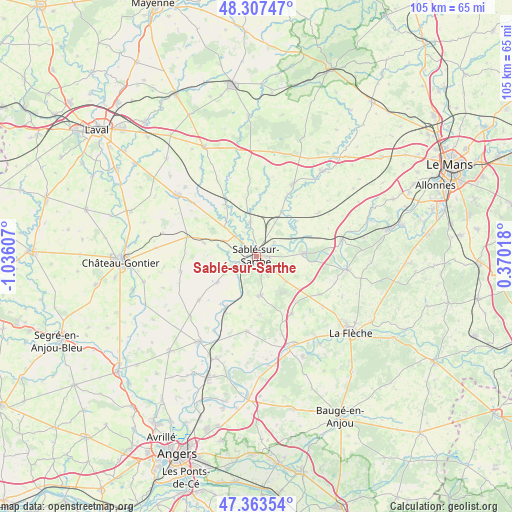
Sablé-sur-Sarthe GPS coordinates[2]
47° 50' 15.54" North, 0° 19' 58.584" West
| Map corner | latitude | longitude |
|---|---|---|
| Upper-left | 48.30747°, | -1.03607° |
| Center: | 47.83765°, | -0.33294° |
| Lower-right: | 47.36354°, | 0.37018° |
| Map W x H: | 105×105 km | = 65.2×65.2mi |
| max Lat: | 51.07786° ⇑43.5% North |
| Sablé-sur-Sarthe: | 47.83765° |
| min Lat: | ⇓56.5% South 41.3874° |
| min Long | Sablé-sur-Sart | max Long |
| -5.08615° | -0.33294° | 9.52242° |
| W 18.8%⇐ | ⇒81.2% E |
Elevation
Elevation of Sablé-sur-Sarthe is 39 m = 128 ft, and this is 154.7 m = 508 ft below average elevation for this country.
| Max E: |
2333 m = 7654 ft | 86.2% |
| Avg. | 193.7 m = 635 ft | |
| Sablé-sur-Sarthe | 39 m = 128 ft | |
Min E: |
-1 m = -3 ft | 13.8% |
See also: France elevation on elevation.city.
Geographical zone
Sablé-sur-Sarthe is located in North temperate zone (between Tropic of Cancer and the Arctic Circle). Distance of this North polar circle is 2082.1 km =1293.8 mi to North.| Distance of | km | miles | from Sablé-sur-Sarthe |
|---|---|---|---|
| North Pole | 4688 | 2913 | to North |
| Arctic Circle | 2082.1 | 1293.8 | to North |
| Tropic Cancer | 2713.1 | 1685.8 | to South |
| Equator | 5319 | 3305.1 | to South |


Nearby cities:
15 places around Sablé-sur-Sarthe: (largest is in red/bold)
• Auvers-le-Hamon
7.3 km =4.5 mi,  349°
349°
• Avoise
9.9 km =6.2 mi,  70°
70°
• Ballée
12.4 km =7.7 mi,  328°
328°
• Bouessay
6.3 km =3.9 mi,  311°
311°
• Bouère
11.1 km =6.9 mi,  284°
284°
• Courtillers
4.7 km =2.9 mi,  150°
150°
• Juigné-sur-Sarthe
4.6 km =2.9 mi,  48°
48°
• Louailles
7.9 km =4.9 mi,  129°
129°
• Morannes
12.2 km =7.6 mi,  210°
210°
• Parcé-sur-Sarthe
9.9 km =6.2 mi,  86°
86°
• Poillé-sur-Vègre
10.4 km =6.5 mi,  28°
28°
• Précigné
7.9 km =4.9 mi,  175°
175°
• Solesmes
2.9 km =1.8 mi,  62°
62°
• Souvigné-sur-Sarthe
4.3 km =2.7 mi,  253°
253°
• Vion
7.3 km =4.5 mi,  106°
106°
Sources, notices
• [Note1] Compared only with cities in France existing in our database
• [Src1] Map data: © OpenStreetMap contributors (CC-BY-SA)
• [Src2] Other city data from geonames.org with taken over terms of usage.
• [Src3] Geographical zone / Annual Mean Temperature by Robert A. Rohde @ Wikipedia
