Chantenay-Villedieu geodata
Chantenay-Villedieu (Pays de la Loire) is a populated place; located in France in Europe/Paris (GMT+2) time zone. With population of 763 people, there are 11026 cities with bigger population in this country. Compared to other cities in France, 57.9% of cities are located further ↓South; 79.3% of cities are located further →East and 79.4% of cities have higher elevation than Chantenay-Villedieu. Note1
Administrative division(s):
- Level 1: Pays de la Loire
- Level 2: Sarthe
- Level 3: Arrondissement de La Flèche
- Level 4: Chantenay-Villedieu


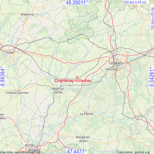
Chantenay-Villedieu GPS coordinates[2]
47° 55' 15.78" North, 0° 9' 37.872" West
| Map corner | latitude | longitude |
|---|---|---|
| Upper-left | 48.39011°, | -0.86364° |
| Center: | 47.92105°, | -0.16052° |
| Lower-right: | 47.4477°, | 0.54261° |
| Map W x H: | 104.8×104.8 km | = 65.1×65.1mi |
| max Lat: | 51.07786° ⇑42.1% North |
| Chantenay-Villedieu: | 47.92105° |
| min Lat: | ⇓57.9% South 41.3874° |
| min Long | Chantenay-Ville | max Long |
| -5.08615° | -0.16052° | 9.52242° |
| W 20.7%⇐ | ⇒79.3% E |
Elevation
Elevation of Chantenay-Villedieu is 56 m = 184 ft, and this is 137.7 m = 452 ft below average elevation for this country.
| Max E: |
2333 m = 7654 ft | 79.4% |
| Avg. | 193.7 m = 635 ft | |
| Chantenay-Villedieu | 56 m = 184 ft | |
Min E: |
-1 m = -3 ft | 20.6% |
See also: France elevation on elevation.city.
Geographical zone
Chantenay-Villedieu is located in North temperate zone (between Tropic of Cancer and the Arctic Circle). Distance of this North polar circle is 2072.9 km =1288 mi to North.| Distance of | km | miles | from Chantenay-Villedieu |
|---|---|---|---|
| North Pole | 4678.7 | 2907.2 | to North |
| Arctic Circle | 2072.9 | 1288 | to North |
| Tropic Cancer | 2722.4 | 1691.6 | to South |
| Equator | 5328.3 | 3310.9 | to South |


Nearby cities:
15 places around Chantenay-Villedieu: (largest is in red/bold)
• Avoise
7 km =4.3 mi,  210°
210°
• Brûlon
7.4 km =4.6 mi,  313°
313°
• Chemiré-le-Gaudin
10.8 km =6.7 mi,  85°
85°
• Fercé-sur-Sarthe
9.8 km =6.1 mi,  102°
102°
• Joué-en-Charnie
11 km =6.8 mi,  348°
348°
• Juigné-sur-Sarthe
11.3 km =7 mi,  236°
236°
• Louplande
8.8 km =5.5 mi,  68°
68°
• Loué
8.3 km =5.2 mi,  3°
3°
• Noyen-sur-Sarthe
7.1 km =4.4 mi,  140°
140°
• Parcé-sur-Sarthe
9.1 km =5.7 mi,  199°
199°
• Poillé-sur-Vègre
7.9 km =4.9 mi,  268°
268°
• Saint-Jean-du-Bois
10.6 km =6.6 mi,  121°
121°
• Solesmes
12.9 km =8 mi,  232°
232°
• Vallon-sur-Gée
8.3 km =5.2 mi,  55°
55°
• Vion
12.8 km =8 mi, 207°
Sources, notices
• [Note1] Compared only with cities in France existing in our database
• [Src1] Map data: © OpenStreetMap contributors (CC-BY-SA)
• [Src2] Other city data from geonames.org with taken over terms of usage.
• [Src3] Geographical zone / Annual Mean Temperature by Robert A. Rohde @ Wikipedia
