Précigné geodata
Précigné (Pays de la Loire) is a populated place; located in France in Europe/Paris (GMT+2) time zone. With population of 2,768 people, there are 3532 cities with bigger population in this country. Compared to other cities in France, 55.3% of cities are located further ↓South; 81.1% of cities are located further →East and 87.4% of cities have higher elevation than Précigné. Note1
Administrative division(s):
- Level 1: Pays de la Loire
- Level 2: Sarthe
- Level 3: Arrondissement de La Flèche
- Level 4: Précigné


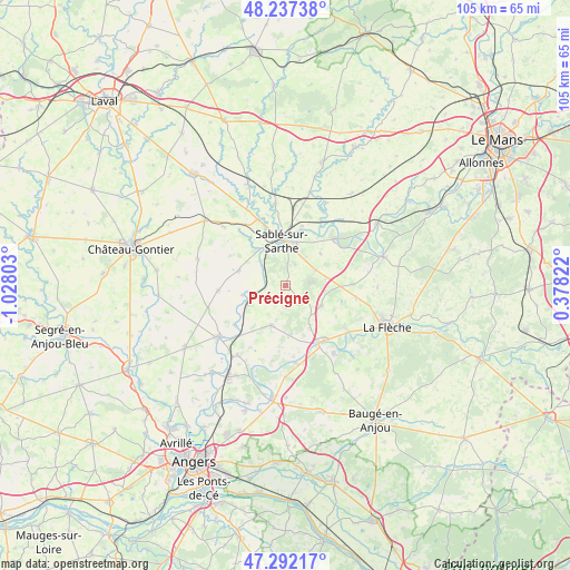
Précigné GPS coordinates[2]
47° 46' 0.912" North, 0° 19' 29.676" West
| Map corner | latitude | longitude |
|---|---|---|
| Upper-left | 48.23738°, | -1.02803° |
| Center: | 47.76692°, | -0.32491° |
| Lower-right: | 47.29217°, | 0.37822° |
| Map W x H: | 105.1×105.1 km | = 65.3×65.3mi |
| max Lat: | 51.07786° ⇑44.7% North |
| Précigné: | 47.76692° |
| min Lat: | ⇓55.3% South 41.3874° |
| min Long | Précigné | max Long |
| -5.08615° | -0.32491° | 9.52242° |
| W 18.9%⇐ | ⇒81.1% E |
Elevation
Elevation of Précigné is 36 m = 118 ft, and this is 157.7 m = 517 ft below average elevation for this country.
| Max E: |
2333 m = 7654 ft | 87.4% |
| Avg. | 193.7 m = 635 ft | |
| Précigné | 36 m = 118 ft | |
Min E: |
-1 m = -3 ft | 12.6% |
See also: France elevation on elevation.city.
Geographical zone
Précigné is located in North temperate zone (between Tropic of Cancer and the Arctic Circle). Distance of this North polar circle is 2090 km =1298.7 mi to North.| Distance of | km | miles | from Précigné |
|---|---|---|---|
| North Pole | 4695.9 | 2917.9 | to North |
| Arctic Circle | 2090 | 1298.7 | to North |
| Tropic Cancer | 2705.3 | 1681 | to South |
| Equator | 5311.2 | 3300.2 | to South |


Nearby cities:
15 places around Précigné: (largest is in red/bold)
• Brissarthe
11.8 km =7.3 mi,  231°
231°
• Courtillers
4.1 km =2.5 mi,  24°
24°
• Crosmières
13.2 km =8.2 mi,  100°
100°
• Daumeray
7.8 km =4.8 mi,  200°
200°
• Durtal
12.5 km =7.8 mi,  147°
147°
• Juigné
7.4 km =4.6 mi,  224°
224°
• Juigné-sur-Sarthe
11.3 km =7 mi,  14°
14°
• Louailles
6.1 km =3.8 mi,  63°
63°
• Miré
12.5 km =7.8 mi,  265°
265°
• Morannes
7.3 km =4.5 mi,  249°
249°
• Parcé-sur-Sarthe
12.6 km =7.8 mi,  47°
47°
• Sablé-sur-Sarthe
7.9 km =4.9 mi,  355°
355°
• Solesmes
9.5 km =5.9 mi, 12°
• Souvigné-sur-Sarthe
8.2 km =5.1 mi,  324°
324°
• Vion
8.7 km =5.4 mi, 47°
Sources, notices
• [Note1] Compared only with cities in France existing in our database
• [Src1] Map data: © OpenStreetMap contributors (CC-BY-SA)
• [Src2] Other city data from geonames.org with taken over terms of usage.
• [Src3] Geographical zone / Annual Mean Temperature by Robert A. Rohde @ Wikipedia
