Siran geodata
Siran (Auvergne-Rhône-Alpes) is a populated place; located in France in Europe/Paris (GMT+2) time zone. With population of 536 people, there are 14480 cities with bigger population in this country. Compared to other cities in France, 80% of cities are located further ↑North; 55.4% of cities are located further →East and 95.9% of cities have lower elevation than Siran. Note1
Administrative division(s):
- Level 1: Auvergne-Rhône-Alpes
- Level 2: Cantal
- Level 3: Aurillac
- Level 4: Siran


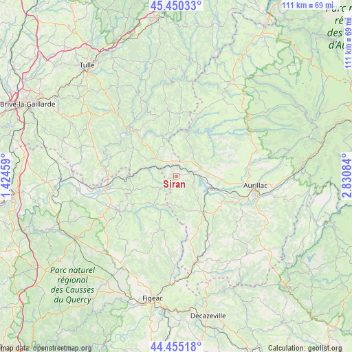
Siran GPS coordinates[2]
44° 57' 17.676" North, 2° 7' 39.756" East
| Map corner | latitude | longitude |
|---|---|---|
| Upper-left | 45.45033°, | 1.42459° |
| Center: | 44.95491°, | 2.12771° |
| Lower-right: | 44.45518°, | 2.83084° |
| Map W x H: | 110.7×110.6 km | = 68.8×68.7mi |
| max Lat: | 51.07786° ⇑80% North |
| Siran: | 44.95491° |
| min Lat: | ⇓20% South 41.3874° |
| min Long | Siran | max Long |
| -5.08615° | 2.12771° | 9.52242° |
| W 44.6%⇐ | ⇒55.4% E |
Elevation
Elevation of Siran is 639 m = 2096 ft, and this is 445.3 m = 1461 ft above average elevation for this country.
| Max E: |
2333 m = 7654 ft | 4.1% |
| Siran | 639 m 2096 ft | |
| Avg. | 193.7 m = 635 ft | |
Min E: |
-1 m = -3 ft | 95.9% |
See also: France elevation on elevation.city.
Geographical zone
Siran is located in North temperate zone (between Tropic of Cancer and the Arctic Circle). Distance of this Northern Tropic circle is 2392.6 km =1486.7 mi to South.| Distance of | km | miles | from Siran |
|---|---|---|---|
| North Pole | 5008.5 | 3112.1 | to North |
| Arctic Circle | 2402.7 | 1493 | to North |
| Tropic Cancer | 2392.6 | 1486.7 | to South |
| Equator | 4998.5 | 3105.9 | to South |


Nearby cities:
15 places around Siran: (largest is in red/bold)
• Ayrens
16 km =9.9 mi,  78°
78°
• Laroquebrou
5.2 km =3.2 mi,  73°
73°
• Latronquière
17.6 km =10.9 mi,  192°
192°
• Le Rouget
13.8 km =8.6 mi,  143°
143°
• Saint-Céré
21.4 km =13.3 mi,  239°
239°
• Saint-Illide
18.9 km =11.7 mi,  51°
51°
• Saint-Julien-aux-Bois
19.5 km =12.1 mi,  2°
2°
• Saint-Laurent-les-Tours
20.2 km =12.6 mi, 244°
• Saint-Mamet-la-Salvetat
17.7 km =11 mi,  127°
127°
• Saint-Paul-des-Landes
14.7 km =9.1 mi,  94°
94°
• Saint-Privat
20.5 km =12.7 mi,  353°
353°
• Sansac-de-Marmiesse
19 km =11.8 mi,  114°
114°
• Servières-le-Château
21.1 km =13.1 mi,  337°
337°
• Sousceyrac
11.6 km =7.2 mi,  218°
218°
• Ytrac
19.1 km =11.9 mi,  104°
104°
Sources, notices
• [Note1] Compared only with cities in France existing in our database
• [Src1] Map data: © OpenStreetMap contributors (CC-BY-SA)
• [Src2] Other city data from geonames.org with taken over terms of usage.
• [Src3] Geographical zone / Annual Mean Temperature by Robert A. Rohde @ Wikipedia
