Servières-le-Château geodata
Servières-le-Château (Nouvelle-Aquitaine) is a populated place; located in France in Europe/Paris (GMT+2) time zone. With population of 733 people, there are 11372 cities with bigger population in this country. Compared to other cities in France, 78.2% of cities are located further ↑North; 56.8% of cities are located further →East and 93.1% of cities have lower elevation than Servières-le-Château. Note1
Administrative division(s):
- Level 1: Nouvelle-Aquitaine
- Level 2: Département de la Corrèze
- Level 3: Arrondissement de Tulle
- Level 4: Servières-le-Château


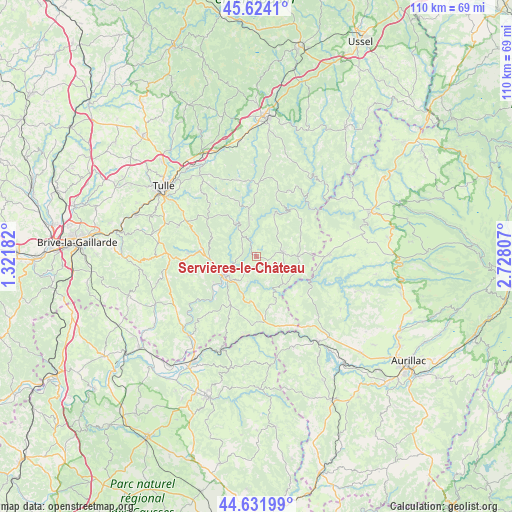
Servières-le-Château GPS coordinates[2]
45° 7' 48.72" North, 2° 1' 29.82" East
| Map corner | latitude | longitude |
|---|---|---|
| Upper-left | 45.6241°, | 1.32182° |
| Center: | 45.1302°, | 2.02495° |
| Lower-right: | 44.63199°, | 2.72807° |
| Map W x H: | 110.3×110.3 km | = 68.5×68.5mi |
| max Lat: | 51.07786° ⇑78.2% North |
| Servières-le-Château: | 45.1302° |
| min Lat: | ⇓21.8% South 41.3874° |
| min Long | Servières-le-C | max Long |
| -5.08615° | 2.02495° | 9.52242° |
| W 43.2%⇐ | ⇒56.8% E |
Elevation
Elevation of Servières-le-Château is 509 m = 1670 ft, and this is 315.3 m = 1034 ft above average elevation for this country.
| Max E: |
2333 m = 7654 ft | 6.9% |
| Servières-le-Château | 509 m 1670 ft | |
| Avg. | 193.7 m = 635 ft | |
Min E: |
-1 m = -3 ft | 93.1% |
See also: France elevation on elevation.city.
Geographical zone
Servières-le-Château is located in North temperate zone (between Tropic of Cancer and the Arctic Circle). Distance of this North polar circle is 2383.2 km =1480.9 mi to North.| Distance of | km | miles | from Servières-le-Château |
|---|---|---|---|
| North Pole | 4989.1 | 3100.1 | to North |
| Arctic Circle | 2383.2 | 1480.9 | to North |
| Tropic Cancer | 2412.1 | 1498.8 | to South |
| Equator | 5018 | 3118 | to South |


Nearby cities:
15 places around Servières-le-Château: (largest is in red/bold)
• Albussac
14.9 km =9.3 mi,  273°
273°
• Altillac
21.9 km =13.6 mi,  219°
219°
• Argentat
8 km =5 mi,  239°
239°
• Chanac-les-Mines
21.9 km =13.6 mi,  312°
312°
• Lagarde-Enval
18.2 km =11.3 mi,  290°
290°
• Laroquebrou
22.2 km =13.8 mi,  143°
143°
• Marcillac-la-Croisille
15.8 km =9.8 mi,  1°
1°
• Monceaux-sur-Dordogne
10.7 km =6.6 mi, 239°
• Pleaux
15.8 km =9.8 mi,  88°
88°
• Saint-Chamant
10.2 km =6.3 mi, 267°
• Saint-Julien-aux-Bois
9 km =5.6 mi, 90°
• Saint-Privat
5.9 km =3.7 mi,  81°
81°
• Sainte-Fortunade
21.6 km =13.4 mi, 293°
• Siran
21.1 km =13.1 mi,  157°
157°
• Soursac
21.2 km =13.2 mi,  40°
40°
Sources, notices
• [Note1] Compared only with cities in France existing in our database
• [Src1] Map data: © OpenStreetMap contributors (CC-BY-SA)
• [Src2] Other city data from geonames.org with taken over terms of usage.
• [Src3] Geographical zone / Annual Mean Temperature by Robert A. Rohde @ Wikipedia
