Saint-Pierre-sur-Orthe geodata
Saint-Pierre-sur-Orthe (Pays de la Loire) is a populated place; located in France in Europe/Paris (GMT+2) time zone. With population of 556 people, there are 14098 cities with bigger population in this country. Compared to other cities in France, 63% of cities are located further ↓South; 79.7% of cities are located further →East and 55.3% of cities have lower elevation than Saint-Pierre-sur-Orthe. Note1
Administrative division(s):
- Level 1: Pays de la Loire
- Level 2: Mayenne
- Level 3: Arrondissement de Mayenne
- Level 4: Saint-Pierre-sur-Orthe
Current local time in Saint-Pierre-sur-Orthe:
07:29 PM, SaturdayDifference from your time zone: hours


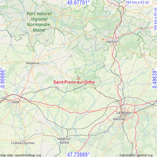
Saint-Pierre-sur-Orthe GPS coordinates[2]
48° 12' 38.124" North, 0° 12' 24.264" West
| Map corner | latitude | longitude |
|---|---|---|
| Upper-left | 48.67701°, | -0.90986° |
| Center: | 48.21059°, | -0.20674° |
| Lower-right: | 47.73989°, | 0.49639° |
| Map W x H: | 104.2×104.2 km | = 64.7×64.7mi |
| max Lat: | 51.07786° ⇑37% North |
| Saint-Pierre-sur-Orthe: | 48.21059° |
| min Lat: | ⇓63% South 41.3874° |
| min Long | Saint-Pierre-su | max Long |
| -5.08615° | -0.20674° | 9.52242° |
| W 20.3%⇐ | ⇒79.7% E |
Elevation
Elevation of Saint-Pierre-sur-Orthe is 151 m = 495 ft, and this is 42.7 m = 140 ft below average elevation for this country.
| Max E: |
2333 m = 7654 ft | 44.7% |
| Avg. | 193.7 m = 635 ft | |
| Saint-Pierre-sur-Orthe | 151 m = 495 ft | |
Min E: |
-1 m = -3 ft | 55.3% |
See also: France elevation on elevation.city.
Geographical zone
Saint-Pierre-sur-Orthe is located in North temperate zone (between Tropic of Cancer and the Arctic Circle). Distance of this North polar circle is 2040.7 km =1268 mi to North.| Distance of | km | miles | from Saint-Pierre-sur-Orthe |
|---|---|---|---|
| North Pole | 4646.5 | 2887.2 | to North |
| Arctic Circle | 2040.7 | 1268 | to North |
| Tropic Cancer | 2754.6 | 1711.6 | to South |
| Equator | 5360.5 | 3330.9 | to South |


Nearby cities:
15 places around Saint-Pierre-sur-Orthe: (largest is in red/bold)
• Averton
13.5 km =8.4 mi,  355°
355°
• Bais
12.6 km =7.8 mi,  291°
291°
• Champgenéteux
14.6 km =9.1 mi,  307°
307°
• Courcité
11.1 km =6.9 mi,  343°
343°
• Crissé
11.8 km =7.3 mi,  113°
113°
• Mont-Saint-Jean
8.1 km =5 mi,  62°
62°
• Parennes
10.3 km =6.4 mi,  170°
170°
• Rouessé-Vassé
4.9 km =3 mi, 174°
• Rouez
10.5 km =6.5 mi,  139°
139°
• Saint-Georges-le-Gaultier
12.1 km =7.5 mi,  37°
37°
• Saint-Rémy-de-Sillé
8.8 km =5.5 mi, 107°
• Sainte-Gemmes-le-Robert
12.7 km =7.9 mi,  262°
262°
• Sillé-le-Guillaume
6.7 km =4.2 mi,  117°
117°
• Torcé-Viviers-en-Charnie
13.1 km =8.1 mi,  199°
199°
• Voutré
10.4 km =6.5 mi,  217°
217°
Sources, notices
• [Note1] Compared only with cities in France existing in our database
• [Src1] Map data: © OpenStreetMap contributors (CC-BY-SA)
• [Src2] Other city data from geonames.org with taken over terms of usage.
• [Src3] Geographical zone / Annual Mean Temperature by Robert A. Rohde @ Wikipedia
