Doussard geodata
Doussard (Auvergne-Rhône-Alpes) is a populated place; located in France in Europe/Paris (GMT+2) time zone. With population of 3,076 people, there are 3172 cities with bigger population in this country. Compared to other cities in France, 69.6% of cities are located further ↑North; 89.5% of cities are located further ←West and 91.7% of cities have lower elevation than Doussard. Note1
Administrative division(s):
- Level 1: Auvergne-Rhône-Alpes
- Level 2: Haute-Savoie
- Level 3: Annecy
- Level 4: Doussard


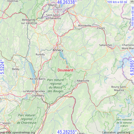
Doussard GPS coordinates[2]
45° 46' 30.432" North, 6° 13' 31.908" East
| Map corner | latitude | longitude |
|---|---|---|
| Upper-left | 46.26338°, | 5.5224° |
| Center: | 45.77512°, | 6.22553° |
| Lower-right: | 45.28255°, | 6.92865° |
| Map W x H: | 109.1×109.1 km | = 67.8×67.8mi |
| max Lat: | 51.07786° ⇑69.6% North |
| Doussard: | 45.77512° |
| min Lat: | ⇓30.4% South 41.3874° |
| min Long | Doussard | max Long |
| -5.08615° | 6.22553° | 9.52242° |
| W 89.5%⇐ | ⇒10.5% E |
Elevation
Elevation of Doussard is 466 m = 1529 ft, and this is 272.3 m = 893 ft above average elevation for this country.
| Max E: |
2333 m = 7654 ft | 8.3% |
| Doussard | 466 m 1529 ft | |
| Avg. | 193.7 m = 635 ft | |
Min E: |
-1 m = -3 ft | 91.7% |
See also: France elevation on elevation.city.
Geographical zone
Doussard is located in North temperate zone (between Tropic of Cancer and the Arctic Circle). Distance of this North polar circle is 2311.5 km =1436.3 mi to North.| Distance of | km | miles | from Doussard |
|---|---|---|---|
| North Pole | 4917.3 | 3055.5 | to North |
| Arctic Circle | 2311.5 | 1436.3 | to North |
| Tropic Cancer | 2483.8 | 1543.4 | to South |
| Equator | 5089.7 | 3162.6 | to South |


Nearby cities:
15 places around Doussard: (largest is in red/bold)
• Duingt
5.9 km =3.7 mi,  341°
341°
• Faverges
5.8 km =3.6 mi,  117°
117°
• Lathuile
1.9 km =1.2 mi,  301°
301°
• Le Châtelard
12.1 km =7.5 mi,  214°
214°
• Les Clefs
12.5 km =7.8 mi,  40°
40°
• Lescheraines
11.6 km =7.2 mi,  233°
233°
• Marlens
9.3 km =5.8 mi,  96°
96°
• Menthon-Saint-Bernard
9.7 km =6 mi,  346°
346°
• Saint-Ferréol
6.6 km =4.1 mi, 100°
• Saint-Jorioz
8.1 km =5 mi,  319°
319°
• Serraval
9.3 km =5.8 mi,  72°
72°
• Sevrier
11.9 km =7.4 mi,  326°
326°
• Seythenex
7.9 km =4.9 mi,  133°
133°
• Talloires
7.4 km =4.6 mi, 352°
• Veyrier-du-Lac
12.5 km =7.8 mi, 342°
Sources, notices
• [Note1] Compared only with cities in France existing in our database
• [Src1] Map data: © OpenStreetMap contributors (CC-BY-SA)
• [Src2] Other city data from geonames.org with taken over terms of usage.
• [Src3] Geographical zone / Annual Mean Temperature by Robert A. Rohde @ Wikipedia
