Saint-Barthélemy-de-Vals geodata
Saint-Barthélemy-de-Vals (Auvergne-Rhône-Alpes) is a populated place; located in France in Europe/Paris (GMT+2) time zone. With population of 1,728 people, there are 5453 cities with bigger population in this country. Compared to other cities in France, 77.8% of cities are located further ↑North; 76.1% of cities are located further ←West and 61.3% of cities have lower elevation than Saint-Barthélemy-de-Vals. Note1
Administrative division(s):
- Level 1: Auvergne-Rhône-Alpes
- Level 2: Département de la Drôme
- Level 3: Arrondissement de Valence
- Level 4: Saint-Barthélemy-de-Vals
Current local time in Saint-Barthélemy-de-Vals:
02:56 PM, MondayDifference from your time zone: hours


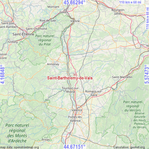
Saint-Barthélemy-de-Vals GPS coordinates[2]
45° 10' 9.768" North, 4° 52' 17.76" East
| Map corner | latitude | longitude |
|---|---|---|
| Upper-left | 45.66294°, | 4.16848° |
| Center: | 45.16938°, | 4.8716° |
| Lower-right: | 44.67151°, | 5.57473° |
| Map W x H: | 110.2×110.2 km | = 68.5×68.5mi |
| max Lat: | 51.07786° ⇑77.8% North |
| Saint-Barthélemy-de-Vals: | 45.16938° |
| min Lat: | ⇓22.2% South 41.3874° |
| min Long | Saint-Barthéle | max Long |
| -5.08615° | 4.8716° | 9.52242° |
| W 76.1%⇐ | ⇒23.9% E |
Elevation
Elevation of Saint-Barthélemy-de-Vals is 176 m = 577 ft, and this is 17.7 m = 58 ft below average elevation for this country.
| Max E: |
2333 m = 7654 ft | 38.7% |
| Avg. | 193.7 m = 635 ft | |
| Saint-Barthélemy-de-Vals | 176 m = 577 ft | |
Min E: |
-1 m = -3 ft | 61.3% |
See also: France elevation on elevation.city.
Geographical zone
Saint-Barthélemy-de-Vals is located in North temperate zone (between Tropic of Cancer and the Arctic Circle). Distance of this North polar circle is 2378.8 km =1478.1 mi to North.| Distance of | km | miles | from Saint-Barthélemy-de-Vals |
|---|---|---|---|
| North Pole | 4984.7 | 3097.3 | to North |
| Arctic Circle | 2378.8 | 1478.1 | to North |
| Tropic Cancer | 2416.4 | 1501.5 | to South |
| Equator | 5022.4 | 3120.8 | to South |


Nearby cities:
15 places around Saint-Barthélemy-de-Vals: (largest is in red/bold)
• Beausemblant
6.1 km =3.8 mi,  329°
329°
• Bren
6.9 km =4.3 mi,  121°
121°
• Chantemerle-les-Blés
6.3 km =3.9 mi,  162°
162°
• Claveyson
4.8 km =3 mi,  77°
77°
• Eclassan
8.7 km =5.4 mi,  261°
261°
• La Motte-de-Galaure
4.2 km =2.6 mi,  42°
42°
• Larnage
8.1 km =5 mi,  184°
184°
• Laveyron
6.1 km =3.8 mi,  318°
318°
• Saint-Uze
1.9 km =1.2 mi, 330°
• Saint-Vallier
4.2 km =2.6 mi,  273°
273°
• Sarras
5.9 km =3.7 mi,  289°
289°
• Serves-sur-Rhône
5.7 km =3.5 mi,  228°
228°
• Talencieux
9.4 km =5.8 mi,  308°
308°
• Vion
8.3 km =5.2 mi,  217°
217°
• Érôme
6.7 km =4.2 mi, 217°
Sources, notices
• [Note1] Compared only with cities in France existing in our database
• [Src1] Map data: © OpenStreetMap contributors (CC-BY-SA)
• [Src2] Other city data from geonames.org with taken over terms of usage.
• [Src3] Geographical zone / Annual Mean Temperature by Robert A. Rohde @ Wikipedia
