Vion geodata
Vion (Auvergne-Rhône-Alpes) is a populated place; located in France in Europe/Paris (GMT+2) time zone. With population of 790 people, there are 10715 cities with bigger population in this country. Compared to other cities in France, 78.5% of cities are located further ↑North; 75.1% of cities are located further ←West and 52% of cities have higher elevation than Vion. Note1
Administrative division(s):
- Level 1: Auvergne-Rhône-Alpes
- Level 2: Département de l'Ardèche
- Level 3: Arrondissement de Tournon-sur-Rhône
- Level 4: Vion


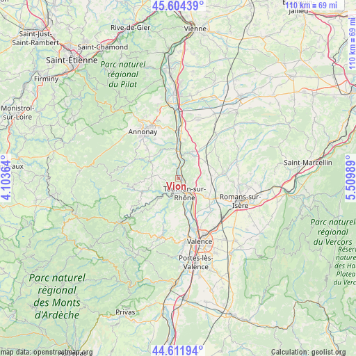
Vion GPS coordinates[2]
45° 6' 37.152" North, 4° 48' 24.336" East
| Map corner | latitude | longitude |
|---|---|---|
| Upper-left | 45.60439°, | 4.10364° |
| Center: | 45.11032°, | 4.80676° |
| Lower-right: | 44.61194°, | 5.50989° |
| Map W x H: | 110.4×110.3 km | = 68.6×68.5mi |
| max Lat: | 51.07786° ⇑78.5% North |
| Vion: | 45.11032° |
| min Lat: | ⇓21.5% South 41.3874° |
| min Long | Vion | max Long |
| -5.08615° | 4.80676° | 9.52242° |
| W 75.1%⇐ | ⇒24.9% E |
Elevation
Elevation of Vion is 125 m = 410 ft, and this is 68.7 m = 225 ft below average elevation for this country.
| Max E: |
2333 m = 7654 ft | 52% |
| Avg. | 193.7 m = 635 ft | |
| Vion | 125 m = 410 ft | |
Min E: |
-1 m = -3 ft | 48% |
See also: France elevation on elevation.city.
Geographical zone
Vion is located in North temperate zone (between Tropic of Cancer and the Arctic Circle). Distance of this North polar circle is 2385.4 km =1482.2 mi to North.| Distance of | km | miles | from Vion |
|---|---|---|---|
| North Pole | 4991.3 | 3101.4 | to North |
| Arctic Circle | 2385.4 | 1482.2 | to North |
| Tropic Cancer | 2409.9 | 1497.4 | to South |
| Equator | 5015.8 | 3116.7 | to South |


Nearby cities:
15 places around Vion: (largest is in red/bold)
• Chantemerle-les-Blés
7 km =4.3 mi,  85°
85°
• Eclassan
6.4 km =4 mi,  326°
326°
• Larnage
4.7 km =2.9 mi,  108°
108°
• Lemps
3.3 km =2.1 mi,  267°
267°
• Mauves
8.2 km =5.1 mi,  167°
167°
• Mercurol-Veaunes
7.8 km =4.8 mi,  120°
120°
• Saint-Barthélemy-de-Vals
8.3 km =5.2 mi,  37°
37°
• Saint-Barthélemy-le-Plain
7.8 km =4.8 mi,  217°
217°
• Saint-Jean-de-Muzols
3.2 km =2 mi, 169°
• Saint-Vallier
6.9 km =4.3 mi,  7°
7°
• Serves-sur-Rhône
2.9 km =1.8 mi,  16°
16°
• Tain-l’Hermitage
6.2 km =3.9 mi,  141°
141°
• Tournon-sur-Rhône
5.3 km =3.3 mi,  156°
156°
• Érôme
1.6 km =1 mi, 40°
• Étables
6.5 km =4 mi,  260°
260°
Sources, notices
• [Note1] Compared only with cities in France existing in our database
• [Src1] Map data: © OpenStreetMap contributors (CC-BY-SA)
• [Src2] Other city data from geonames.org with taken over terms of usage.
• [Src3] Geographical zone / Annual Mean Temperature by Robert A. Rohde @ Wikipedia
