Lemps geodata
Lemps (Auvergne-Rhône-Alpes) is a populated place; located in France in Europe/Paris (GMT+2) time zone. With population of 604 people, there are 13253 cities with bigger population in this country. Compared to other cities in France, 78.5% of cities are located further ↑North; 74.6% of cities are located further ←West and 89.9% of cities have lower elevation than Lemps. Note1
Administrative division(s):
- Level 1: Auvergne-Rhône-Alpes
- Level 2: Département de l'Ardèche
- Level 3: Arrondissement de Tournon-sur-Rhône
- Level 4: Lemps


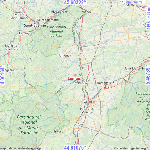
Lemps GPS coordinates[2]
45° 6' 32.904" North, 4° 45' 53.136" East
| Map corner | latitude | longitude |
|---|---|---|
| Upper-left | 45.60322°, | 4.06164° |
| Center: | 45.10914°, | 4.76476° |
| Lower-right: | 44.61075°, | 5.46789° |
| Map W x H: | 110.4×110.4 km | = 68.6×68.6mi |
| max Lat: | 51.07786° ⇑78.5% North |
| Lemps: | 45.10914° |
| min Lat: | ⇓21.5% South 41.3874° |
| min Long | Lemps | max Long |
| -5.08615° | 4.76476° | 9.52242° |
| W 74.6%⇐ | ⇒25.4% E |
Elevation
Elevation of Lemps is 424 m = 1391 ft, and this is 230.3 m = 756 ft above average elevation for this country.
| Max E: |
2333 m = 7654 ft | 10.1% |
| Lemps | 424 m 1391 ft | |
| Avg. | 193.7 m = 635 ft | |
Min E: |
-1 m = -3 ft | 89.9% |
See also: France elevation on elevation.city.
Geographical zone
Lemps is located in North temperate zone (between Tropic of Cancer and the Arctic Circle). Distance of this North polar circle is 2385.5 km =1482.3 mi to North.| Distance of | km | miles | from Lemps |
|---|---|---|---|
| North Pole | 4991.4 | 3101.5 | to North |
| Arctic Circle | 2385.5 | 1482.3 | to North |
| Tropic Cancer | 2409.7 | 1497.3 | to South |
| Equator | 5015.7 | 3116.6 | to South |


Nearby cities:
15 places around Lemps: (largest is in red/bold)
• Ardoix
8.9 km =5.5 mi,  345°
345°
• Colombier-le-Vieux
7.2 km =4.5 mi,  227°
227°
• Eclassan
5.5 km =3.4 mi,  357°
357°
• Larnage
7.9 km =4.9 mi,  100°
100°
• Saint-Barthélemy-le-Plain
6.3 km =3.9 mi,  193°
193°
• Saint-Jean-de-Muzols
4.9 km =3 mi,  128°
128°
• Saint-Vallier
8.1 km =5 mi,  30°
30°
• Saint-Victor
7.3 km =4.5 mi,  262°
262°
• Sarras
9.1 km =5.7 mi,  17°
17°
• Serves-sur-Rhône
5 km =3.1 mi,  55°
55°
• Tain-l’Hermitage
8.6 km =5.3 mi,  123°
123°
• Tournon-sur-Rhône
7.2 km =4.5 mi, 131°
• Vion
3.3 km =2.1 mi,  87°
87°
• Érôme
4.5 km =2.8 mi,  72°
72°
• Étables
3.2 km =2 mi,  253°
253°
Sources, notices
• [Note1] Compared only with cities in France existing in our database
• [Src1] Map data: © OpenStreetMap contributors (CC-BY-SA)
• [Src2] Other city data from geonames.org with taken over terms of usage.
• [Src3] Geographical zone / Annual Mean Temperature by Robert A. Rohde @ Wikipedia
