Érôme geodata
Érôme (Auvergne-Rhône-Alpes) is a populated place; located in France in Europe/Paris (GMT+2) time zone. With population of 736 people, there are 11334 cities with bigger population in this country. Compared to other cities in France, 78.3% of cities are located further ↑North; 75.4% of cities are located further ←West and 64.2% of cities have lower elevation than Érôme. Note1
Administrative division(s):
- Level 1: Auvergne-Rhône-Alpes
- Level 2: Département de la Drôme
- Level 3: Arrondissement de Valence
- Level 4: Érôme


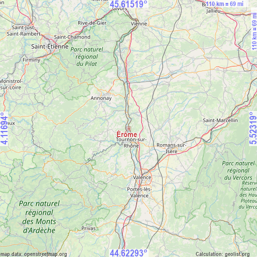
Érôme GPS coordinates[2]
45° 7' 16.392" North, 4° 49' 12.252" East
| Map corner | latitude | longitude |
|---|---|---|
| Upper-left | 45.61519°, | 4.11694° |
| Center: | 45.12122°, | 4.82007° |
| Lower-right: | 44.62293°, | 5.52319° |
| Map W x H: | 110.3×110.3 km | = 68.5×68.5mi |
| max Lat: | 51.07786° ⇑78.3% North |
| Érôme: | 45.12122° |
| min Lat: | ⇓21.7% South 41.3874° |
| min Long | Érôme | max Long |
| -5.08615° | 4.82007° | 9.52242° |
| W 75.4%⇐ | ⇒24.6% E |
Elevation
Elevation of Érôme is 190 m = 623 ft, and this is 3.7 m = 12 ft below average elevation for this country.
| Max E: |
2333 m = 7654 ft | 35.8% |
| Avg. | 193.7 m = 635 ft | |
| Érôme | 190 m = 623 ft | |
Min E: |
-1 m = -3 ft | 64.2% |
See also: France elevation on elevation.city.
Geographical zone
Érôme is located in North temperate zone (between Tropic of Cancer and the Arctic Circle). Distance of this North polar circle is 2384.2 km =1481.5 mi to North.| Distance of | km | miles | from Érôme |
|---|---|---|---|
| North Pole | 4990.1 | 3100.7 | to North |
| Arctic Circle | 2384.2 | 1481.5 | to North |
| Tropic Cancer | 2411.1 | 1498.2 | to South |
| Equator | 5017 | 3117.4 | to South |


Nearby cities:
15 places around Érôme: (largest is in red/bold)
• Chantemerle-les-Blés
6 km =3.7 mi,  95°
95°
• Eclassan
6.2 km =3.9 mi,  311°
311°
• Larnage
4.4 km =2.7 mi,  128°
128°
• Lemps
4.5 km =2.8 mi,  252°
252°
• Mercurol-Veaunes
7.7 km =4.8 mi, 132°
• Saint-Barthélemy-de-Vals
6.7 km =4.2 mi,  37°
37°
• Saint-Jean-de-Muzols
4.4 km =2.7 mi,  186°
186°
• Saint-Uze
7.7 km =4.8 mi,  24°
24°
• Saint-Vallier
5.6 km =3.5 mi,  358°
358°
• Sarras
7.5 km =4.7 mi,  347°
347°
• Serves-sur-Rhône
1.6 km =1 mi, 352°
• Tain-l’Hermitage
6.7 km =4.2 mi,  155°
155°
• Tournon-sur-Rhône
6.2 km =3.9 mi,  170°
170°
• Vion
1.6 km =1 mi,  220°
220°
• Étables
7.8 km =4.8 mi, 253°
Sources, notices
• [Note1] Compared only with cities in France existing in our database
• [Src1] Map data: © OpenStreetMap contributors (CC-BY-SA)
• [Src2] Other city data from geonames.org with taken over terms of usage.
• [Src3] Geographical zone / Annual Mean Temperature by Robert A. Rohde @ Wikipedia
