Sérigné geodata
Sérigné (Pays de la Loire) is a populated place; located in France in Europe/Paris (GMT+2) time zone. With population of 1,010 people, there are 8771 cities with bigger population in this country. Compared to other cities in France, 60.1% of cities are located further ↑North; 86.8% of cities are located further →East and 83.4% of cities have higher elevation than Sérigné. Note1
Administrative division(s):
- Level 1: Pays de la Loire
- Level 2: Département de la Vendée
- Level 3: Arrondissement de Fontenay-le-Comte
- Level 4: Sérigné


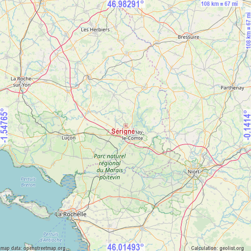
Sérigné GPS coordinates[2]
46° 30' 3.852" North, 0° 50' 40.308" West
| Map corner | latitude | longitude |
|---|---|---|
| Upper-left | 46.98291°, | -1.54765° |
| Center: | 46.50107°, | -0.84453° |
| Lower-right: | 46.01493°, | -0.1414° |
| Map W x H: | 107.6×107.6 km | = 66.9×66.9mi |
| max Lat: | 51.07786° ⇑60.1% North |
| Sérigné: | 46.50107° |
| min Lat: | ⇓39.9% South 41.3874° |
| min Long | Sérigné | max Long |
| -5.08615° | -0.84453° | 9.52242° |
| W 13.2%⇐ | ⇒86.8% E |
Elevation
Elevation of Sérigné is 46 m = 151 ft, and this is 147.7 m = 485 ft below average elevation for this country.
| Max E: |
2333 m = 7654 ft | 83.4% |
| Avg. | 193.7 m = 635 ft | |
| Sérigné | 46 m = 151 ft | |
Min E: |
-1 m = -3 ft | 16.6% |
See also: France elevation on elevation.city.
Geographical zone
Sérigné is located in North temperate zone (between Tropic of Cancer and the Arctic Circle). Distance of this North polar circle is 2230.7 km =1386.1 mi to North.| Distance of | km | miles | from Sérigné |
|---|---|---|---|
| North Pole | 4836.6 | 3005.3 | to North |
| Arctic Circle | 2230.7 | 1386.1 | to North |
| Tropic Cancer | 2564.5 | 1593.5 | to South |
| Equator | 5170.4 | 3212.7 | to South |


Nearby cities:
15 places around Sérigné: (largest is in red/bold)
• Auzay
6.5 km =4 mi,  190°
190°
• Bourneau
4.7 km =2.9 mi,  26°
26°
• Fontaines
8.7 km =5.4 mi,  169°
169°
• Fontenay-le-Comte
4.8 km =3 mi,  142°
142°
• Le Langon
10.5 km =6.5 mi,  228°
228°
• Marsais-Sainte-Radégonde
4.9 km =3 mi,  326°
326°
• Mervent
7.1 km =4.4 mi,  70°
70°
• Montreuil
10.4 km =6.5 mi,  177°
177°
• Petosse
5.9 km =3.7 mi,  250°
250°
• Pissotte
2.9 km =1.8 mi,  98°
98°
• Pouillé
8 km =5 mi,  274°
274°
• Saint-Cyr-des-Gâts
8.2 km =5.1 mi,  338°
338°
• Saint-Martin-de-Fraigneau
10.5 km =6.5 mi,  133°
133°
• Saint-Michel-le-Cloucq
7.3 km =4.5 mi, 104°
• Vouvant
9.8 km =6.1 mi,  36°
36°
Sources, notices
• [Note1] Compared only with cities in France existing in our database
• [Src1] Map data: © OpenStreetMap contributors (CC-BY-SA)
• [Src2] Other city data from geonames.org with taken over terms of usage.
• [Src3] Geographical zone / Annual Mean Temperature by Robert A. Rohde @ Wikipedia
