Saint-Michel-le-Cloucq geodata
Saint-Michel-le-Cloucq (Pays de la Loire) is a populated place; located in France in Europe/Paris (GMT+2) time zone. With population of 1,320 people, there are 6939 cities with bigger population in this country. Compared to other cities in France, 60.2% of cities are located further ↑North; 86% of cities are located further →East and 65.3% of cities have higher elevation than Saint-Michel-le-Cloucq. Note1
Administrative division(s):
- Level 1: Pays de la Loire
- Level 2: Département de la Vendée
- Level 3: Arrondissement de Fontenay-le-Comte
- Level 4: Saint-Michel-le-Cloucq
Current local time in Saint-Michel-le-Cloucq:
09:34 AM, SaturdayDifference from your time zone: hours


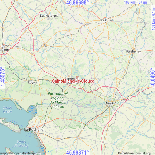
Saint-Michel-le-Cloucq GPS coordinates[2]
46° 29' 6" North, 0° 45' 9.432" West
| Map corner | latitude | longitude |
|---|---|---|
| Upper-left | 46.96698°, | -1.45575° |
| Center: | 46.485°, | -0.75262° |
| Lower-right: | 45.99871°, | -0.0495° |
| Map W x H: | 107.7×107.7 km | = 66.9×66.9mi |
| max Lat: | 51.07786° ⇑60.2% North |
| Saint-Michel-le-Cloucq: | 46.485° |
| min Lat: | ⇓39.8% South 41.3874° |
| min Long | Saint-Michel-le | max Long |
| -5.08615° | -0.75262° | 9.52242° |
| W 14%⇐ | ⇒86% E |
Elevation
Elevation of Saint-Michel-le-Cloucq is 89 m = 292 ft, and this is 104.7 m = 344 ft below average elevation for this country.
| Max E: |
2333 m = 7654 ft | 65.3% |
| Avg. | 193.7 m = 635 ft | |
| Saint-Michel-le-Cloucq | 89 m = 292 ft | |
Min E: |
-1 m = -3 ft | 34.7% |
See also: France elevation on elevation.city.
Geographical zone
Saint-Michel-le-Cloucq is located in North temperate zone (between Tropic of Cancer and the Arctic Circle). Distance of this North polar circle is 2232.5 km =1387.2 mi to North.| Distance of | km | miles | from Saint-Michel-le-Cloucq |
|---|---|---|---|
| North Pole | 4838.4 | 3006.4 | to North |
| Arctic Circle | 2232.5 | 1387.2 | to North |
| Tropic Cancer | 2562.7 | 1592.4 | to South |
| Equator | 5168.6 | 3211.6 | to South |


Nearby cities:
15 places around Saint-Michel-le-Cloucq: (largest is in red/bold)
• Auzay
9.4 km =5.8 mi,  240°
240°
• Bourneau
7.8 km =4.8 mi,  320°
320°
• Doix
11.1 km =6.9 mi,  201°
201°
• Fontaines
8.6 km =5.3 mi,  218°
218°
• Fontenay-le-Comte
4.6 km =2.9 mi, 244°
• Foussais-Payré
7.5 km =4.7 mi,  44°
44°
• Mervent
4.2 km =2.6 mi,  355°
355°
• Montreuil
10.8 km =6.7 mi, 217°
• Pissotte
4.4 km =2.7 mi,  288°
288°
• Saint-Hilaire-des-Loges
6.9 km =4.3 mi,  102°
102°
• Saint-Martin-de-Fraigneau
5.5 km =3.4 mi,  174°
174°
• Saint-Pierre-le-Vieux
10.9 km =6.8 mi,  178°
178°
• Sérigné
7.3 km =4.5 mi,  284°
284°
• Vouvant
9.7 km =6 mi,  352°
352°
• Xanton-Chassenon
5.6 km =3.5 mi,  128°
128°
Sources, notices
• [Note1] Compared only with cities in France existing in our database
• [Src1] Map data: © OpenStreetMap contributors (CC-BY-SA)
• [Src2] Other city data from geonames.org with taken over terms of usage.
• [Src3] Geographical zone / Annual Mean Temperature by Robert A. Rohde @ Wikipedia
