Marsais-Sainte-Radégonde geodata
Marsais-Sainte-Radégonde (Pays de la Loire) is a populated place; located in France in Europe/Paris (GMT+2) time zone. With population of 525 people, there are 14719 cities with bigger population in this country. Compared to other cities in France, 59.8% of cities are located further ↑North; 87.1% of cities are located further →East and 75.4% of cities have higher elevation than Marsais-Sainte-Radégonde. Note1
Administrative division(s):
- Level 1: Pays de la Loire
- Level 2: Département de la Vendée
- Level 3: Arrondissement de Fontenay-le-Comte
- Level 4: Marsais-Sainte-Radégonde
Current local time in Marsais-Sainte-Radégonde:
09:29 AM, SaturdayDifference from your time zone: hours


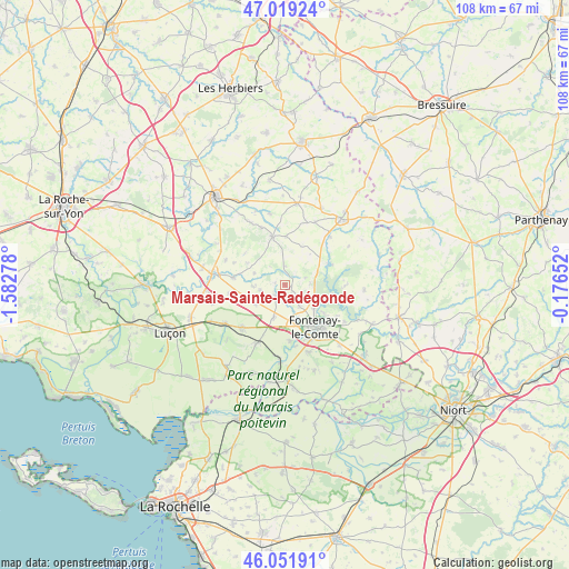
Marsais-Sainte-Radégonde GPS coordinates[2]
46° 32' 15.828" North, 0° 52' 46.74" West
| Map corner | latitude | longitude |
|---|---|---|
| Upper-left | 47.01924°, | -1.58278° |
| Center: | 46.53773°, | -0.87965° |
| Lower-right: | 46.05191°, | -0.17652° |
| Map W x H: | 107.6×107.6 km | = 66.9×66.9mi |
| max Lat: | 51.07786° ⇑59.8% North |
| Marsais-Sainte-Radégonde: | 46.53773° |
| min Lat: | ⇓40.2% South 41.3874° |
| min Long | Marsais-Sainte- | max Long |
| -5.08615° | -0.87965° | 9.52242° |
| W 12.9%⇐ | ⇒87.1% E |
Elevation
Elevation of Marsais-Sainte-Radégonde is 66 m = 217 ft, and this is 127.7 m = 419 ft below average elevation for this country.
| Max E: |
2333 m = 7654 ft | 75.4% |
| Avg. | 193.7 m = 635 ft | |
| Marsais-Sainte-Radégonde | 66 m = 217 ft | |
Min E: |
-1 m = -3 ft | 24.6% |
See also: France elevation on elevation.city.
Geographical zone
Marsais-Sainte-Radégonde is located in North temperate zone (between Tropic of Cancer and the Arctic Circle). Distance of this North polar circle is 2226.7 km =1383.6 mi to North.| Distance of | km | miles | from Marsais-Sainte-Radégonde |
|---|---|---|---|
| North Pole | 4832.6 | 3002.8 | to North |
| Arctic Circle | 2226.7 | 1383.6 | to North |
| Tropic Cancer | 2568.6 | 1596.1 | to South |
| Equator | 5174.5 | 3215.3 | to South |


Nearby cities:
15 places around Marsais-Sainte-Radégonde: (largest is in red/bold)
• Antigny
12.5 km =7.8 mi,  42°
42°
• Auzay
10.5 km =6.5 mi,  171°
171°
• Bourneau
4.8 km =3 mi,  88°
88°
• Fontenay-le-Comte
9.6 km =6 mi,  144°
144°
• Le Langon
12.2 km =7.6 mi,  205°
205°
• Mervent
9.6 km =6 mi,  100°
100°
• Petosse
6.7 km =4.2 mi, 205°
• Pissotte
7.2 km =4.5 mi,  128°
128°
• Pouillé
6.4 km =4 mi,  236°
236°
• Saint-Cyr-des-Gâts
3.5 km =2.2 mi,  355°
355°
• Saint-Martin-sous-Mouzeuil
12.1 km =7.5 mi,  223°
223°
• Saint-Michel-le-Cloucq
11.4 km =7.1 mi,  121°
121°
• Sérigné
4.9 km =3 mi,  146°
146°
• Thouarsais-Bouildroux
9.1 km =5.7 mi, 359°
• Vouvant
9.3 km =5.8 mi,  65°
65°
Sources, notices
• [Note1] Compared only with cities in France existing in our database
• [Src1] Map data: © OpenStreetMap contributors (CC-BY-SA)
• [Src2] Other city data from geonames.org with taken over terms of usage.
• [Src3] Geographical zone / Annual Mean Temperature by Robert A. Rohde @ Wikipedia
