Saveuse geodata
Saveuse (Hauts-de-France) is a populated place; located in France in Europe/Paris (GMT+2) time zone. With population of 801 people, there are 10598 cities with bigger population in this country. Compared to other cities in France, 93% of cities are located further ↓South; 54.1% of cities are located further →East and 78.6% of cities have higher elevation than Saveuse. Note1
Administrative division(s):
- Level 1: Hauts-de-France
- Level 2: Somme
- Level 3: Amiens
- Level 4: Saveuse


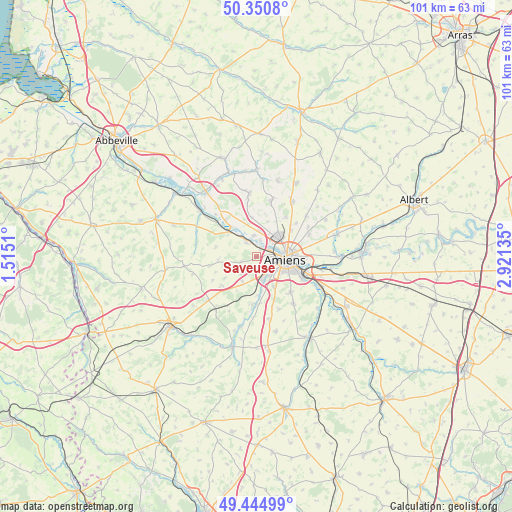
Saveuse GPS coordinates[2]
49° 54' 0.072" North, 2° 13' 5.628" East
| Map corner | latitude | longitude |
|---|---|---|
| Upper-left | 50.3508°, | 1.5151° |
| Center: | 49.90002°, | 2.21823° |
| Lower-right: | 49.44499°, | 2.92135° |
| Map W x H: | 100.7×100.7 km | = 62.6×62.6mi |
| max Lat: | 51.07786° ⇑7% North |
| Saveuse: | 49.90002° |
| min Lat: | ⇓93% South 41.3874° |
| min Long | Saveuse | max Long |
| -5.08615° | 2.21823° | 9.52242° |
| W 45.9%⇐ | ⇒54.1% E |
Elevation
Elevation of Saveuse is 58 m = 190 ft, and this is 135.7 m = 445 ft below average elevation for this country.
| Max E: |
2333 m = 7654 ft | 78.6% |
| Avg. | 193.7 m = 635 ft | |
| Saveuse | 58 m = 190 ft | |
Min E: |
-1 m = -3 ft | 21.4% |
See also: France elevation on elevation.city.
Geographical zone
Saveuse is located in North temperate zone (between Tropic of Cancer and the Arctic Circle). Distance of this North polar circle is 1852.8 km =1151.3 mi to North.| Distance of | km | miles | from Saveuse |
|---|---|---|---|
| North Pole | 4458.7 | 2770.5 | to North |
| Arctic Circle | 1852.8 | 1151.3 | to North |
| Tropic Cancer | 2942.4 | 1828.3 | to South |
| Equator | 5548.4 | 3447.6 | to South |


Nearby cities:
15 places around Saveuse: (largest is in red/bold)
• Ailly-sur-Somme
3.6 km =2.2 mi,  333°
333°
• Amiens
5.9 km =3.7 mi,  90°
90°
• Argoeuves
3.4 km =2.1 mi,  11°
11°
• Bacouel-sur-Selle
7.8 km =4.8 mi,  176°
176°
• Dreuil-lès-Amiens
1.8 km =1.1 mi,  24°
24°
• Dury
7 km =4.3 mi,  147°
147°
• La Chaussée-Tirancourt
7.7 km =4.8 mi,  320°
320°
• Picquigny
7.2 km =4.5 mi,  312°
312°
• Pont-de-Metz
3 km =1.9 mi,  144°
144°
• Rivery
7.5 km =4.7 mi, 87°
• Saint-Sauveur
4.2 km =2.6 mi,  353°
353°
• Saint-Vaast-en-Chaussée
7.5 km =4.7 mi, 350°
• Saleux
5 km =3.1 mi,  164°
164°
• Salouël
3.8 km =2.4 mi, 151°
• Vers-sur-Selles
7.5 km =4.7 mi,  171°
171°
Sources, notices
• [Note1] Compared only with cities in France existing in our database
• [Src1] Map data: © OpenStreetMap contributors (CC-BY-SA)
• [Src2] Other city data from geonames.org with taken over terms of usage.
• [Src3] Geographical zone / Annual Mean Temperature by Robert A. Rohde @ Wikipedia
