Argoeuves geodata
Argoeuves (Hauts-de-France) is a populated place; located in France in Europe/Paris (GMT+2) time zone. With population of 564 people, there are 13934 cities with bigger population in this country. Compared to other cities in France, 93.2% of cities are located further ↓South; 53.9% of cities are located further →East and 92.7% of cities have higher elevation than Argoeuves. Note1
Administrative division(s):
- Level 1: Hauts-de-France
- Level 2: Somme
- Level 3: Amiens
- Level 4: Argœuves


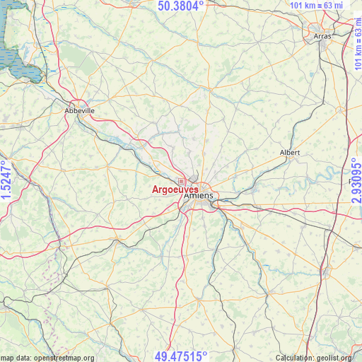
Argoeuves GPS coordinates[2]
49° 55' 47.64" North, 2° 13' 40.152" East
| Map corner | latitude | longitude |
|---|---|---|
| Upper-left | 50.3804°, | 1.5247° |
| Center: | 49.9299°, | 2.22782° |
| Lower-right: | 49.47515°, | 2.93095° |
| Map W x H: | 100.7×100.7 km | = 62.6×62.6mi |
| max Lat: | 51.07786° ⇑6.8% North |
| Argoeuves: | 49.9299° |
| min Lat: | ⇓93.2% South 41.3874° |
| min Long | Argoeuves | max Long |
| -5.08615° | 2.22782° | 9.52242° |
| W 46.1%⇐ | ⇒53.9% E |
Elevation
Elevation of Argoeuves is 23 m = 75 ft, and this is 170.7 m = 560 ft below average elevation for this country.
| Max E: |
2333 m = 7654 ft | 92.7% |
| Avg. | 193.7 m = 635 ft | |
| Argoeuves | 23 m = 75 ft | |
Min E: |
-1 m = -3 ft | 7.3% |
See also: France elevation on elevation.city.
Geographical zone
Argoeuves is located in North temperate zone (between Tropic of Cancer and the Arctic Circle). Distance of this North polar circle is 1849.5 km =1149.2 mi to North.| Distance of | km | miles | from Argoeuves |
|---|---|---|---|
| North Pole | 4455.4 | 2768.5 | to North |
| Arctic Circle | 1849.5 | 1149.2 | to North |
| Tropic Cancer | 2945.8 | 1830.4 | to South |
| Equator | 5551.7 | 3449.7 | to South |


Nearby cities:
15 places around Argoeuves: (largest is in red/bold)
• Ailly-sur-Somme
2.3 km =1.4 mi,  267°
267°
• Amiens
6.1 km =3.8 mi,  122°
122°
• Bertangles
6.8 km =4.2 mi,  48°
48°
• Dreuil-lès-Amiens
1.7 km =1.1 mi,  177°
177°
• Flesselles
8.4 km =5.2 mi,  16°
16°
• La Chaussée-Tirancourt
6.2 km =3.9 mi,  295°
295°
• Picquigny
6.2 km =3.9 mi,  284°
284°
• Pont-de-Metz
5.8 km =3.6 mi,  169°
169°
• Poulainville
6.5 km =4 mi,  72°
72°
• Rivery
7.4 km =4.6 mi,  113°
113°
• Saint-Sauveur
1.5 km =0.9 mi,  307°
307°
• Saint-Vaast-en-Chaussée
4.5 km =2.8 mi,  334°
334°
• Saleux
8.2 km =5.1 mi, 175°
• Salouël
6.8 km =4.2 mi, 170°
• Saveuse
3.4 km =2.1 mi,  191°
191°
Sources, notices
• [Note1] Compared only with cities in France existing in our database
• [Src1] Map data: © OpenStreetMap contributors (CC-BY-SA)
• [Src2] Other city data from geonames.org with taken over terms of usage.
• [Src3] Geographical zone / Annual Mean Temperature by Robert A. Rohde @ Wikipedia
