Pont-de-Metz geodata
Pont-de-Metz (Hauts-de-France) is a populated place; located in France in Europe/Paris (GMT+2) time zone. With population of 1,682 people, there are 5567 cities with bigger population in this country. Compared to other cities in France, 92.8% of cities are located further ↓South; 53.6% of cities are located further →East and 90.3% of cities have higher elevation than Pont-de-Metz. Note1
Administrative division(s):
- Level 1: Hauts-de-France
- Level 2: Somme
- Level 3: Amiens
- Level 4: Pont-de-Metz


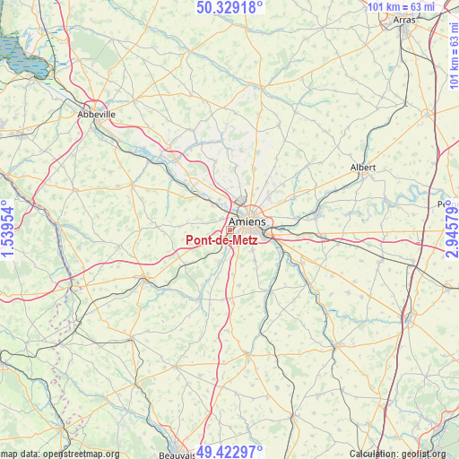
Pont-de-Metz GPS coordinates[2]
49° 52' 41.52" North, 2° 14' 33.576" East
| Map corner | latitude | longitude |
|---|---|---|
| Upper-left | 50.32918°, | 1.53954° |
| Center: | 49.8782°, | 2.24266° |
| Lower-right: | 49.42297°, | 2.94579° |
| Map W x H: | 100.8×100.8 km | = 62.6×62.6mi |
| max Lat: | 51.07786° ⇑7.2% North |
| Pont-de-Metz: | 49.8782° |
| min Lat: | ⇓92.8% South 41.3874° |
| min Long | Pont-de-Metz | max Long |
| -5.08615° | 2.24266° | 9.52242° |
| W 46.4%⇐ | ⇒53.6% E |
Elevation
Elevation of Pont-de-Metz is 29 m = 95 ft, and this is 164.7 m = 540 ft below average elevation for this country.
| Max E: |
2333 m = 7654 ft | 90.3% |
| Avg. | 193.7 m = 635 ft | |
| Pont-de-Metz | 29 m = 95 ft | |
Min E: |
-1 m = -3 ft | 9.7% |
See also: France elevation on elevation.city.
Geographical zone
Pont-de-Metz is located in North temperate zone (between Tropic of Cancer and the Arctic Circle). Distance of this North polar circle is 1855.2 km =1152.8 mi to North.| Distance of | km | miles | from Pont-de-Metz |
|---|---|---|---|
| North Pole | 4461.1 | 2772 | to North |
| Arctic Circle | 1855.2 | 1152.8 | to North |
| Tropic Cancer | 2940 | 1826.8 | to South |
| Equator | 5545.9 | 3446.1 | to South |


Nearby cities:
15 places around Pont-de-Metz: (largest is in red/bold)
• Ailly-sur-Somme
6.5 km =4 mi,  329°
329°
• Amiens
4.8 km =3 mi,  59°
59°
• Argoeuves
5.8 km =3.6 mi,  349°
349°
• Bacouel-sur-Selle
5.5 km =3.4 mi,  193°
193°
• Dreuil-lès-Amiens
4.2 km =2.6 mi, 346°
• Dury
4 km =2.5 mi,  149°
149°
• Plachy-Buyon
7.3 km =4.5 mi, 194°
• Prouzel
7.3 km =4.5 mi,  203°
203°
• Rivery
6.4 km =4 mi, 63°
• Saint-Fuscien
6.8 km =4.2 mi,  131°
131°
• Saint-Sauveur
7 km =4.3 mi,  341°
341°
• Saleux
2.5 km =1.6 mi, 189°
• Salouël
0.9 km =0.6 mi,  176°
176°
• Saveuse
3 km =1.9 mi,  324°
324°
• Vers-sur-Selles
5 km =3.1 mi, 187°
Sources, notices
• [Note1] Compared only with cities in France existing in our database
• [Src1] Map data: © OpenStreetMap contributors (CC-BY-SA)
• [Src2] Other city data from geonames.org with taken over terms of usage.
• [Src3] Geographical zone / Annual Mean Temperature by Robert A. Rohde @ Wikipedia
