Rivery geodata
Rivery (Hauts-de-France) is a populated place; located in France in Europe/Paris (GMT+2) time zone. With population of 3,454 people, there are 2813 cities with bigger population in this country. Compared to other cities in France, 93% of cities are located further ↓South; 52.3% of cities are located further →East and 84.1% of cities have higher elevation than Rivery. Note1


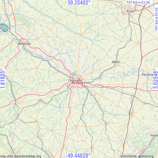
Rivery GPS coordinates[2]
49° 54' 11.808" North, 2° 19' 20.46" East
| Map corner | latitude | longitude |
|---|---|---|
| Upper-left | 50.35402°, | 1.61923° |
| Center: | 49.90328°, | 2.32235° |
| Lower-right: | 49.44828°, | 3.02548° |
| Map W x H: | 100.7×100.7 km | = 62.6×62.6mi |
| max Lat: | 51.07786° ⇑7% North |
| Rivery: | 49.90328° |
| min Lat: | ⇓93% South 41.3874° |
| min Long | Rivery | max Long |
| -5.08615° | 2.32235° | 9.52242° |
| W 47.7%⇐ | ⇒52.3% E |
Elevation
Elevation of Rivery is 44 m = 144 ft, and this is 149.7 m = 491 ft below average elevation for this country.
| Max E: |
2333 m = 7654 ft | 84.1% |
| Avg. | 193.7 m = 635 ft | |
| Rivery | 44 m = 144 ft | |
Min E: |
-1 m = -3 ft | 15.9% |
See also: France elevation on elevation.city.
Geographical zone
Rivery is located in North temperate zone (between Tropic of Cancer and the Arctic Circle). Distance of this North polar circle is 1852.4 km =1151 mi to North.| Distance of | km | miles | from Rivery |
|---|---|---|---|
| North Pole | 4458.3 | 2770.3 | to North |
| Arctic Circle | 1852.4 | 1151 | to North |
| Tropic Cancer | 2942.8 | 1828.6 | to South |
| Equator | 5548.7 | 3447.8 | to South |


Nearby cities:
15 places around Rivery: (largest is in red/bold)
• Allonville
5.1 km =3.2 mi,  35°
35°
• Amiens
1.6 km =1 mi,  257°
257°
• Argoeuves
7.4 km =4.6 mi,  293°
293°
• Bertangles
7.6 km =4.7 mi,  347°
347°
• Cagny
4.8 km =3 mi,  162°
162°
• Camon
2.4 km =1.5 mi,  137°
137°
• Dreuil-lès-Amiens
6.8 km =4.2 mi,  280°
280°
• Dury
7.2 km =4.5 mi,  210°
210°
• Glisy
6.1 km =3.8 mi,  117°
117°
• Longueau
4.3 km =2.7 mi, 142°
• Pont-de-Metz
6.4 km =4 mi,  243°
243°
• Poulainville
4.9 km =3 mi, 352°
• Saint-Fuscien
7.4 km =4.6 mi,  184°
184°
• Salouël
6.8 km =4.2 mi, 236°
• Saveuse
7.5 km =4.7 mi,  267°
267°
Sources, notices
• [Note1] Compared only with cities in France existing in our database
• [Src1] Map data: © OpenStreetMap contributors (CC-BY-SA)
• [Src2] Other city data from geonames.org with taken over terms of usage.
• [Src3] Geographical zone / Annual Mean Temperature by Robert A. Rohde @ Wikipedia
