Salouël geodata
Salouël (Hauts-de-France) is a populated place; located in France in Europe/Paris (GMT+2) time zone. With population of 4,235 people, there are 2324 cities with bigger population in this country. Compared to other cities in France, 92.8% of cities are located further ↓South; 53.6% of cities are located further →East and 89.9% of cities have higher elevation than Salouël. Note1
Administrative division(s):
- Level 1: Hauts-de-France
- Level 2: Somme
- Level 3: Amiens
- Level 4: Salouël


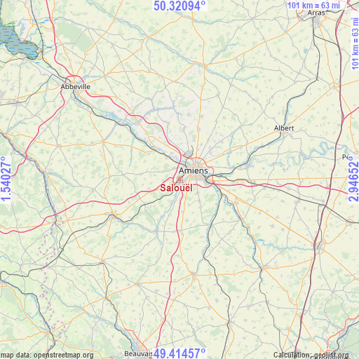
Salouël GPS coordinates[2]
49° 52' 11.568" North, 2° 14' 36.24" East
| Map corner | latitude | longitude |
|---|---|---|
| Upper-left | 50.32094°, | 1.54027° |
| Center: | 49.86988°, | 2.2434° |
| Lower-right: | 49.41457°, | 2.94652° |
| Map W x H: | 100.8×100.8 km | = 62.6×62.6mi |
| max Lat: | 51.07786° ⇑7.2% North |
| Salouël: | 49.86988° |
| min Lat: | ⇓92.8% South 41.3874° |
| min Long | Salouël | max Long |
| -5.08615° | 2.2434° | 9.52242° |
| W 46.4%⇐ | ⇒53.6% E |
Elevation
Elevation of Salouël is 30 m = 98 ft, and this is 163.7 m = 537 ft below average elevation for this country.
| Max E: |
2333 m = 7654 ft | 89.9% |
| Avg. | 193.7 m = 635 ft | |
| Salouël | 30 m = 98 ft | |
Min E: |
-1 m = -3 ft | 10.1% |
See also: France elevation on elevation.city.
Geographical zone
Salouël is located in North temperate zone (between Tropic of Cancer and the Arctic Circle). Distance of this North polar circle is 1856.2 km =1153.4 mi to North.| Distance of | km | miles | from Salouël |
|---|---|---|---|
| North Pole | 4462.1 | 2772.6 | to North |
| Arctic Circle | 1856.2 | 1153.4 | to North |
| Tropic Cancer | 2939.1 | 1826.3 | to South |
| Equator | 5545 | 3445.5 | to South |


Nearby cities:
15 places around Salouël: (largest is in red/bold)
• Amiens
5.3 km =3.3 mi,  50°
50°
• Argoeuves
6.8 km =4.2 mi,  350°
350°
• Bacouel-sur-Selle
4.6 km =2.9 mi,  196°
196°
• Cagny
7.2 km =4.5 mi,  96°
96°
• Dreuil-lès-Amiens
5.1 km =3.2 mi, 348°
• Dury
3.2 km =2 mi,  142°
142°
• Plachy-Buyon
6.4 km =4 mi, 196°
• Pont-de-Metz
0.9 km =0.6 mi,  356°
356°
• Prouzel
6.5 km =4 mi,  207°
207°
• Rivery
6.8 km =4.2 mi,  56°
56°
• Rumigny
7.3 km =4.5 mi,  159°
159°
• Saint-Fuscien
6.2 km =3.9 mi,  125°
125°
• Saleux
1.6 km =1 mi, 196°
• Saveuse
3.8 km =2.4 mi,  331°
331°
• Vers-sur-Selles
4.1 km =2.5 mi,  190°
190°
Sources, notices
• [Note1] Compared only with cities in France existing in our database
• [Src1] Map data: © OpenStreetMap contributors (CC-BY-SA)
• [Src2] Other city data from geonames.org with taken over terms of usage.
• [Src3] Geographical zone / Annual Mean Temperature by Robert A. Rohde @ Wikipedia
