Sauveterre-de-Rouergue geodata
Sauveterre-de-Rouergue (Occitanie) is a populated place; located in France in Europe/Paris (GMT+2) time zone. With population of 807 people, there are 10522 cities with bigger population in this country. Compared to other cities in France, 85.4% of cities are located further ↑North; 52.4% of cities are located further →East and 91.9% of cities have lower elevation than Sauveterre-de-Rouergue. Note1
Administrative division(s):
- Level 1: Occitanie
- Level 2: Département de l'Aveyron
- Level 3: Arrondissement de Villefranche-de-Rouergue
- Level 4: Sauveterre-de-Rouergue
Current local time in Sauveterre-de-Rouergue:
03:37 PM, SaturdayDifference from your time zone: hours


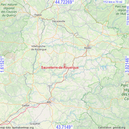
Sauveterre-de-Rouergue GPS coordinates[2]
44° 13' 15.42" North, 2° 19' 5.988" East
| Map corner | latitude | longitude |
|---|---|---|
| Upper-left | 44.72269°, | 1.61521° |
| Center: | 44.22095°, | 2.31833° |
| Lower-right: | 43.7149°, | 3.02146° |
| Map W x H: | 112.1×112.1 km | = 69.7×69.7mi |
| max Lat: | 51.07786° ⇑85.4% North |
| Sauveterre-de-Rouergue: | 44.22095° |
| min Lat: | ⇓14.6% South 41.3874° |
| min Long | Sauveterre-de-R | max Long |
| -5.08615° | 2.31833° | 9.52242° |
| W 47.6%⇐ | ⇒52.4% E |
Elevation
Elevation of Sauveterre-de-Rouergue is 473 m = 1552 ft, and this is 279.3 m = 916 ft above average elevation for this country.
| Max E: |
2333 m = 7654 ft | 8.1% |
| Sauveterre-de-Rouergue | 473 m 1552 ft | |
| Avg. | 193.7 m = 635 ft | |
Min E: |
-1 m = -3 ft | 91.9% |
See also: France elevation on elevation.city.
Geographical zone
Sauveterre-de-Rouergue is located in North temperate zone (between Tropic of Cancer and the Arctic Circle). Distance of this Northern Tropic circle is 2311 km =1436 mi to South.| Distance of | km | miles | from Sauveterre-de-Rouergue |
|---|---|---|---|
| North Pole | 5090.2 | 3162.9 | to North |
| Arctic Circle | 2484.3 | 1543.7 | to North |
| Tropic Cancer | 2311 | 1436 | to South |
| Equator | 4916.9 | 3055.2 | to South |


Nearby cities:
15 places around Sauveterre-de-Rouergue: (largest is in red/bold)
• Baraqueville
11 km =6.8 mi,  55°
55°
• Calmont
15.7 km =9.8 mi,  78°
78°
• Camjac
6.6 km =4.1 mi,  133°
133°
• Centrès
9.6 km =6 mi, 130°
• Colombiès
13.8 km =8.6 mi,  6°
6°
• La Salvetat-Peyralès
9.2 km =5.7 mi,  268°
268°
• Manhac
12.6 km =7.8 mi,  72°
72°
• Mirandol-Bourgnounac
14.8 km =9.2 mi,  233°
233°
• Moyrazès
16.6 km =10.3 mi,  35°
35°
• Naucelle
3.2 km =2 mi,  142°
142°
• Pampelonne
12.2 km =7.6 mi,  208°
208°
• Quins
4.6 km =2.9 mi, 73°
• Rieupeyroux
11.6 km =7.2 mi,  326°
326°
• Sainte-Gemme
17.4 km =10.8 mi, 212°
• Tanus
13.2 km =8.2 mi,  180°
180°
Sources, notices
• [Note1] Compared only with cities in France existing in our database
• [Src1] Map data: © OpenStreetMap contributors (CC-BY-SA)
• [Src2] Other city data from geonames.org with taken over terms of usage.
• [Src3] Geographical zone / Annual Mean Temperature by Robert A. Rohde @ Wikipedia
