Camjac geodata
Camjac (Occitanie) is a populated place; located in France in Europe/Paris (GMT+2) time zone. With population of 572 people, there are 13802 cities with bigger population in this country. Compared to other cities in France, 85.7% of cities are located further ↑North; 51.4% of cities are located further →East and 93.6% of cities have lower elevation than Camjac. Note1
Administrative division(s):
- Level 1: Occitanie
- Level 2: Département de l'Aveyron
- Level 3: Arrondissement de Villefranche-de-Rouergue
- Level 4: Camjac


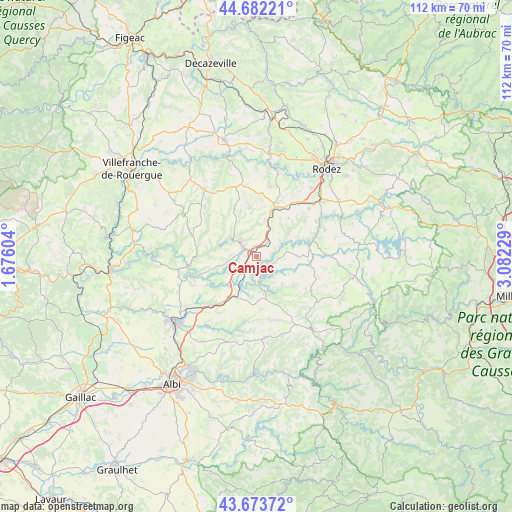
Camjac GPS coordinates[2]
44° 10' 48.432" North, 2° 22' 45.012" East
| Map corner | latitude | longitude |
|---|---|---|
| Upper-left | 44.68221°, | 1.67604° |
| Center: | 44.18012°, | 2.37917° |
| Lower-right: | 43.67372°, | 3.08229° |
| Map W x H: | 112.1×112.1 km | = 69.7×69.7mi |
| max Lat: | 51.07786° ⇑85.7% North |
| Camjac: | 44.18012° |
| min Lat: | ⇓14.3% South 41.3874° |
| min Long | Camjac | max Long |
| -5.08615° | 2.37917° | 9.52242° |
| W 48.6%⇐ | ⇒51.4% E |
Elevation
Elevation of Camjac is 526 m = 1726 ft, and this is 332.3 m = 1090 ft above average elevation for this country.
| Max E: |
2333 m = 7654 ft | 6.4% |
| Camjac | 526 m 1726 ft | |
| Avg. | 193.7 m = 635 ft | |
Min E: |
-1 m = -3 ft | 93.6% |
See also: France elevation on elevation.city.
Geographical zone
Camjac is located in North temperate zone (between Tropic of Cancer and the Arctic Circle). Distance of this Northern Tropic circle is 2306.4 km =1433.1 mi to South.| Distance of | km | miles | from Camjac |
|---|---|---|---|
| North Pole | 5094.7 | 3165.7 | to North |
| Arctic Circle | 2488.8 | 1546.5 | to North |
| Tropic Cancer | 2306.4 | 1433.1 | to South |
| Equator | 4912.4 | 3052.4 | to South |


Nearby cities:
15 places around Camjac: (largest is in red/bold)
• Baraqueville
11.5 km =7.1 mi,  21°
21°
• Calmont
13.1 km =8.1 mi,  54°
54°
• Cassagnes-Bégonhès
12.2 km =7.6 mi,  95°
95°
• Centrès
3 km =1.9 mi,  126°
126°
• La Salvetat-Peyralès
14.7 km =9.1 mi,  287°
287°
• La Selve
14.8 km =9.2 mi,  120°
120°
• Lédergues
11.3 km =7 mi,  153°
153°
• Manhac
10.9 km =6.8 mi,  40°
40°
• Mirandol-Bourgnounac
17.3 km =10.7 mi,  256°
256°
• Naucelle
3.5 km =2.2 mi,  304°
304°
• Pampelonne
12.3 km =7.6 mi,  239°
239°
• Quins
5.9 km =3.7 mi,  355°
355°
• Salmiech
15.5 km =9.6 mi,  89°
89°
• Sauveterre-de-Rouergue
6.6 km =4.1 mi,  313°
313°
• Tanus
10 km =6.2 mi,  209°
209°
Sources, notices
• [Note1] Compared only with cities in France existing in our database
• [Src1] Map data: © OpenStreetMap contributors (CC-BY-SA)
• [Src2] Other city data from geonames.org with taken over terms of usage.
• [Src3] Geographical zone / Annual Mean Temperature by Robert A. Rohde @ Wikipedia
