Manhac geodata
Manhac (Occitanie) is a populated place; located in France in Europe/Paris (GMT+2) time zone. With population of 558 people, there are 14045 cities with bigger population in this country. Compared to other cities in France, 85.1% of cities are located further ↑North; 50.1% of cities are located further ←West and 96.7% of cities have lower elevation than Manhac. Note1
Administrative division(s):
- Level 1: Occitanie
- Level 2: Département de l'Aveyron
- Level 3: Arrondissement de Villefranche-de-Rouergue
- Level 4: Manhac


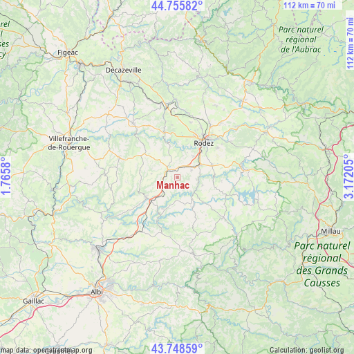
Manhac GPS coordinates[2]
44° 15' 15.696" North, 2° 28' 8.112" East
| Map corner | latitude | longitude |
|---|---|---|
| Upper-left | 44.75582°, | 1.7658° |
| Center: | 44.25436°, | 2.46892° |
| Lower-right: | 43.74859°, | 3.17205° |
| Map W x H: | 112×112 km | = 69.6×69.6mi |
| max Lat: | 51.07786° ⇑85.1% North |
| Manhac: | 44.25436° |
| min Lat: | ⇓14.9% South 41.3874° |
| min Long | Manhac | max Long |
| -5.08615° | 2.46892° | 9.52242° |
| W 50.1%⇐ | ⇒49.9% E |
Elevation
Elevation of Manhac is 703 m = 2306 ft, and this is 509.3 m = 1671 ft above average elevation for this country.
| Max E: |
2333 m = 7654 ft | 3.3% |
| Manhac | 703 m 2306 ft | |
| Avg. | 193.7 m = 635 ft | |
Min E: |
-1 m = -3 ft | 96.7% |
See also: France elevation on elevation.city.
Geographical zone
Manhac is located in North temperate zone (between Tropic of Cancer and the Arctic Circle). Distance of this Northern Tropic circle is 2314.7 km =1438.3 mi to South.| Distance of | km | miles | from Manhac |
|---|---|---|---|
| North Pole | 5086.4 | 3160.5 | to North |
| Arctic Circle | 2480.6 | 1541.4 | to North |
| Tropic Cancer | 2314.7 | 1438.3 | to South |
| Equator | 4920.6 | 3057.5 | to South |


Nearby cities:
15 places around Manhac: (largest is in red/bold)
• Baraqueville
3.8 km =2.4 mi,  309°
309°
• Calmont
3.5 km =2.2 mi,  100°
100°
• Camjac
10.9 km =6.8 mi,  220°
220°
• Cassagnes-Bégonhès
10.7 km =6.6 mi,  152°
152°
• Centrès
11.1 km =6.9 mi,  205°
205°
• Druelle
12.1 km =7.5 mi,  13°
13°
• Flavin
11.5 km =7.1 mi,  70°
70°
• Le Monastère
13.1 km =8.1 mi,  42°
42°
• Luc-la-Primaube
8.5 km =5.3 mi, 38°
• Moyrazès
10 km =6.2 mi,  346°
346°
• Naucelle
11.8 km =7.3 mi,  238°
238°
• Olemps
12.2 km =7.6 mi,  32°
32°
• Quins
7.9 km =4.9 mi,  252°
252°
• Salmiech
11.6 km =7.2 mi,  134°
134°
• Sauveterre-de-Rouergue
12.6 km =7.8 mi, 252°
Sources, notices
• [Note1] Compared only with cities in France existing in our database
• [Src1] Map data: © OpenStreetMap contributors (CC-BY-SA)
• [Src2] Other city data from geonames.org with taken over terms of usage.
• [Src3] Geographical zone / Annual Mean Temperature by Robert A. Rohde @ Wikipedia
