Sauvessanges geodata
Sauvessanges (Auvergne-Rhône-Alpes) is a populated place; located in France in Europe/Paris (GMT+2) time zone. With population of 558 people, there are 14045 cities with bigger population in this country. Compared to other cities in France, 75.3% of cities are located further ↑North; 66.8% of cities are located further ←West and 98.7% of cities have lower elevation than Sauvessanges. Note1
Administrative division(s):
- Level 1: Auvergne-Rhône-Alpes
- Level 2: Département du Puy-de-Dôme
- Level 3: Ambert
- Level 4: Sauvessanges


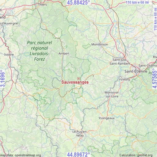
Sauvessanges GPS coordinates[2]
45° 23' 33.504" North, 3° 52' 21.828" East
| Map corner | latitude | longitude |
|---|---|---|
| Upper-left | 45.88425°, | 3.1696° |
| Center: | 45.39264°, | 3.87273° |
| Lower-right: | 44.89672°, | 4.57585° |
| Map W x H: | 109.8×109.8 km | = 68.2×68.2mi |
| max Lat: | 51.07786° ⇑75.3% North |
| Sauvessanges: | 45.39264° |
| min Lat: | ⇓24.7% South 41.3874° |
| min Long | Sauvessanges | max Long |
| -5.08615° | 3.87273° | 9.52242° |
| W 66.8%⇐ | ⇒33.2% E |
Elevation
Elevation of Sauvessanges is 912 m = 2992 ft, and this is 718.3 m = 2357 ft above average elevation for this country.
| Max E: |
2333 m = 7654 ft | 1.3% |
| Sauvessanges | 912 m 2992 ft | |
| Avg. | 193.7 m = 635 ft | |
Min E: |
-1 m = -3 ft | 98.7% |
See also: France elevation on elevation.city.
Geographical zone
Sauvessanges is located in North temperate zone (between Tropic of Cancer and the Arctic Circle). Distance of this North polar circle is 2354 km =1462.7 mi to North.| Distance of | km | miles | from Sauvessanges |
|---|---|---|---|
| North Pole | 4959.9 | 3081.9 | to North |
| Arctic Circle | 2354 | 1462.7 | to North |
| Tropic Cancer | 2441.3 | 1517 | to South |
| Equator | 5047.2 | 3136.2 | to South |


Nearby cities:
15 places around Sauvessanges: (largest is in red/bold)
• Arlanc
11.8 km =7.3 mi,  281°
281°
• Bellevue-la-Montagne
19.6 km =12.2 mi,  192°
192°
• Chomelix
14.9 km =9.3 mi, 193°
• Craponne-sur-Arzon
7.1 km =4.4 mi,  195°
195°
• Estivareilles
11 km =6.8 mi,  75°
75°
• Fontannes
13.2 km =8.2 mi,  220°
220°
• La Chaise-Dieu
15.9 km =9.9 mi,  240°
240°
• Luriecq
17.3 km =10.7 mi,  68°
68°
• Marsac-en-Livradois
14.8 km =9.2 mi,  310°
310°
• Saint-Anthème
15.4 km =9.6 mi,  13°
13°
• Saint-Bonnet-le-Château
15.6 km =9.7 mi, 77°
• Saint-Ferréol-des-Côtes
19.9 km =12.4 mi,  319°
319°
• Saint-Jean-Soleymieux
17.7 km =11 mi,  46°
46°
• Saint-Nizier-de-Fornas
16.4 km =10.2 mi,  85°
85°
• Usson-en-Forez
5.4 km =3.4 mi, 91°
Sources, notices
• [Note1] Compared only with cities in France existing in our database
• [Src1] Map data: © OpenStreetMap contributors (CC-BY-SA)
• [Src2] Other city data from geonames.org with taken over terms of usage.
• [Src3] Geographical zone / Annual Mean Temperature by Robert A. Rohde @ Wikipedia
