Saint-Jean-Soleymieux geodata
Saint-Jean-Soleymieux (Auvergne-Rhône-Alpes) is a populated place; located in France in Europe/Paris (GMT+2) time zone. With population of 738 people, there are 11315 cities with bigger population in this country. Compared to other cities in France, 74.1% of cities are located further ↑North; 68.2% of cities are located further ←West and 97.1% of cities have lower elevation than Saint-Jean-Soleymieux. Note1
Administrative division(s):
- Level 1: Auvergne-Rhône-Alpes
- Level 2: Département de la Loire
- Level 3: Arrondissement de Montbrison
- Level 4: Saint-Jean-Soleymieux
Current local time in Saint-Jean-Soleymieux:
11:32 AM, SaturdayDifference from your time zone: hours


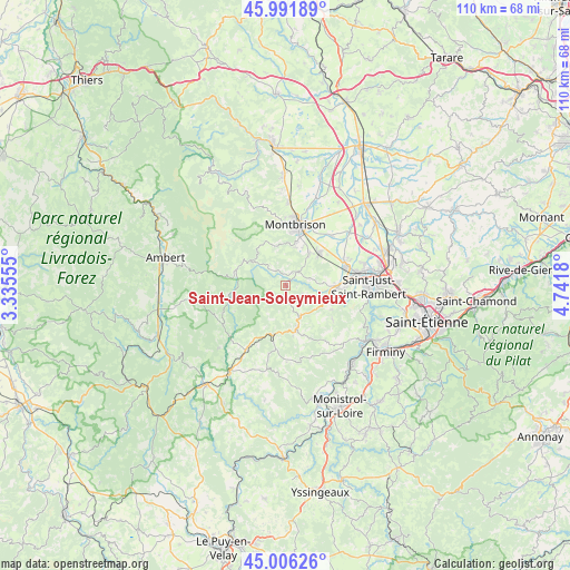
Saint-Jean-Soleymieux GPS coordinates[2]
45° 30' 4.428" North, 4° 2' 19.212" East
| Map corner | latitude | longitude |
|---|---|---|
| Upper-left | 45.99189°, | 3.33555° |
| Center: | 45.50123°, | 4.03867° |
| Lower-right: | 45.00626°, | 4.7418° |
| Map W x H: | 109.6×109.6 km | = 68.1×68.1mi |
| max Lat: | 51.07786° ⇑74.1% North |
| Saint-Jean-Soleymieux: | 45.50123° |
| min Lat: | ⇓25.9% South 41.3874° |
| min Long | Saint-Jean-Sole | max Long |
| -5.08615° | 4.03867° | 9.52242° |
| W 68.2%⇐ | ⇒31.8% E |
Elevation
Elevation of Saint-Jean-Soleymieux is 731 m = 2398 ft, and this is 537.3 m = 1763 ft above average elevation for this country.
| Max E: |
2333 m = 7654 ft | 2.9% |
| Saint-Jean-Soleymieux | 731 m 2398 ft | |
| Avg. | 193.7 m = 635 ft | |
Min E: |
-1 m = -3 ft | 97.1% |
See also: France elevation on elevation.city.
Geographical zone
Saint-Jean-Soleymieux is located in North temperate zone (between Tropic of Cancer and the Arctic Circle). Distance of this North polar circle is 2341.9 km =1455.2 mi to North.| Distance of | km | miles | from Saint-Jean-Soleymieux |
|---|---|---|---|
| North Pole | 4947.8 | 3074.4 | to North |
| Arctic Circle | 2341.9 | 1455.2 | to North |
| Tropic Cancer | 2453.3 | 1524.4 | to South |
| Equator | 5059.3 | 3143.7 | to South |


Nearby cities:
15 places around Saint-Jean-Soleymieux: (largest is in red/bold)
• Bard
9.9 km =6.2 mi,  347°
347°
• Boisset-Saint-Priest
5.3 km =3.3 mi,  75°
75°
• Estivareilles
9.6 km =6 mi,  194°
194°
• Luriecq
6.6 km =4.1 mi,  151°
151°
• Lézigneux
7.5 km =4.7 mi,  16°
16°
• Margerie-Chantagret
3.5 km =2.2 mi,  40°
40°
• Périgneux
11.3 km =7 mi,  126°
126°
• Saint-Anthème
9.9 km =6.2 mi,  287°
287°
• Saint-Bonnet-le-Château
8.9 km =5.5 mi,  165°
165°
• Saint-Georges-Haute-Ville
7.7 km =4.8 mi, 36°
• Saint-Marcellin-en-Forez
10.4 km =6.5 mi,  92°
92°
• Saint-Nizier-de-Fornas
11.3 km =7 mi,  162°
162°
• Saint-Romain-le-Puy
9.1 km =5.7 mi,  45°
45°
• Saint-Thomas-la-Garde
7.9 km =4.9 mi, 23°
• Verrières-en-Forez
8.5 km =5.3 mi,  336°
336°
Sources, notices
• [Note1] Compared only with cities in France existing in our database
• [Src1] Map data: © OpenStreetMap contributors (CC-BY-SA)
• [Src2] Other city data from geonames.org with taken over terms of usage.
• [Src3] Geographical zone / Annual Mean Temperature by Robert A. Rohde @ Wikipedia
