Saugnacq-et-Muret geodata
Saugnacq-et-Muret (Nouvelle-Aquitaine) is a populated place; located in France in Europe/Paris (GMT+2) time zone. With population of 763 people, there are 11026 cities with bigger population in this country. Compared to other cities in France, 84.2% of cities are located further ↑North; 86.3% of cities are located further →East and 84.9% of cities have higher elevation than Saugnacq-et-Muret. Note1
Administrative division(s):
- Level 1: Nouvelle-Aquitaine
- Level 2: Landes
- Level 3: Arrondissement de Mont-de-Marsan
- Level 4: Saugnacq-et-Muret


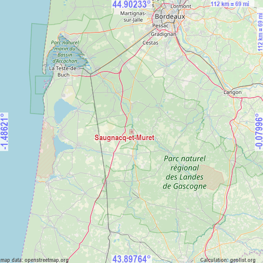
Saugnacq-et-Muret GPS coordinates[2]
44° 24' 7.704" North, 0° 46' 59.124" West
| Map corner | latitude | longitude |
|---|---|---|
| Upper-left | 44.90233°, | -1.48621° |
| Center: | 44.40214°, | -0.78309° |
| Lower-right: | 43.89764°, | -0.07996° |
| Map W x H: | 111.7×111.7 km | = 69.4×69.4mi |
| max Lat: | 51.07786° ⇑84.2% North |
| Saugnacq-et-Muret: | 44.40214° |
| min Lat: | ⇓15.8% South 41.3874° |
| min Long | Saugnacq-et-Mur | max Long |
| -5.08615° | -0.78309° | 9.52242° |
| W 13.7%⇐ | ⇒86.3% E |
Elevation
Elevation of Saugnacq-et-Muret is 42 m = 138 ft, and this is 151.7 m = 498 ft below average elevation for this country.
| Max E: |
2333 m = 7654 ft | 84.9% |
| Avg. | 193.7 m = 635 ft | |
| Saugnacq-et-Muret | 42 m = 138 ft | |
Min E: |
-1 m = -3 ft | 15.1% |
See also: France elevation on elevation.city.
Geographical zone
Saugnacq-et-Muret is located in North temperate zone (between Tropic of Cancer and the Arctic Circle). Distance of this Northern Tropic circle is 2331.1 km =1448.5 mi to South.| Distance of | km | miles | from Saugnacq-et-Muret |
|---|---|---|---|
| North Pole | 5070 | 3150.4 | to North |
| Arctic Circle | 2464.1 | 1531.1 | to North |
| Tropic Cancer | 2331.1 | 1448.5 | to South |
| Equator | 4937.1 | 3067.8 | to South |


Nearby cities:
15 places around Saugnacq-et-Muret: (largest is in red/bold)
• Belin-Béliet
10.9 km =6.8 mi,  359°
359°
• Hostens
15.2 km =9.4 mi,  48°
48°
• Labouheyre
23.7 km =14.7 mi,  207°
207°
• Le Barp
23 km =14.3 mi,  2°
2°
• Louchats
21.2 km =13.2 mi, 54°
• Lugos
11.9 km =7.4 mi,  318°
318°
• Moustey
5.1 km =3.2 mi,  159°
159°
• Parentis-en-Born
23.5 km =14.6 mi,  256°
256°
• Pissos
10.4 km =6.5 mi,  178°
178°
• Saint-Magne
17 km =10.6 mi,  35°
35°
• Saint-Symphorien
23.4 km =14.5 mi,  82°
82°
• Salles
17.6 km =10.9 mi,  339°
339°
• Sanguinet
24.8 km =15.4 mi,  291°
291°
• Sore
18.3 km =11.4 mi,  118°
118°
• Ychoux
15.7 km =9.8 mi,  238°
238°
Sources, notices
• [Note1] Compared only with cities in France existing in our database
• [Src1] Map data: © OpenStreetMap contributors (CC-BY-SA)
• [Src2] Other city data from geonames.org with taken over terms of usage.
• [Src3] Geographical zone / Annual Mean Temperature by Robert A. Rohde @ Wikipedia
