Sore geodata
Sore (Nouvelle-Aquitaine) is a populated place; located in France in Europe/Paris (GMT+2) time zone. With population of 976 people, there are 9012 cities with bigger population in this country. Compared to other cities in France, 84.7% of cities are located further ↑North; 84.3% of cities are located further →East and 71% of cities have higher elevation than Sore. Note1
Administrative division(s):
- Level 1: Nouvelle-Aquitaine
- Level 2: Landes
- Level 3: Arrondissement de Mont-de-Marsan
- Level 4: Sore


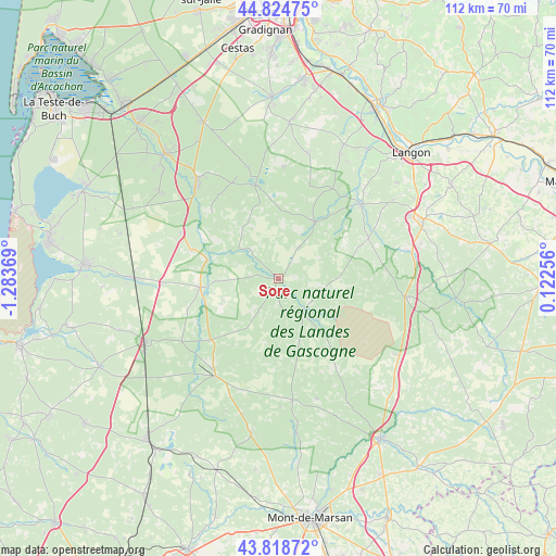
Sore GPS coordinates[2]
44° 19' 26.004" North, 0° 34' 50.052" West
| Map corner | latitude | longitude |
|---|---|---|
| Upper-left | 44.82475°, | -1.28369° |
| Center: | 44.32389°, | -0.58057° |
| Lower-right: | 43.81872°, | 0.12256° |
| Map W x H: | 111.9×111.9 km | = 69.5×69.5mi |
| max Lat: | 51.07786° ⇑84.7% North |
| Sore: | 44.32389° |
| min Lat: | ⇓15.3% South 41.3874° |
| min Long | Sore | max Long |
| -5.08615° | -0.58057° | 9.52242° |
| W 15.7%⇐ | ⇒84.3% E |
Elevation
Elevation of Sore is 76 m = 249 ft, and this is 117.7 m = 386 ft below average elevation for this country.
| Max E: |
2333 m = 7654 ft | 71% |
| Avg. | 193.7 m = 635 ft | |
| Sore | 76 m = 249 ft | |
Min E: |
-1 m = -3 ft | 29% |
See also: France elevation on elevation.city.
Geographical zone
Sore is located in North temperate zone (between Tropic of Cancer and the Arctic Circle). Distance of this Northern Tropic circle is 2322.4 km =1443.1 mi to South.| Distance of | km | miles | from Sore |
|---|---|---|---|
| North Pole | 5078.7 | 3155.8 | to North |
| Arctic Circle | 2472.8 | 1536.5 | to North |
| Tropic Cancer | 2322.4 | 1443.1 | to South |
| Equator | 4928.4 | 3062.4 | to South |


Nearby cities:
15 places around Sore: (largest is in red/bold)
• Belin-Béliet
25.4 km =15.8 mi,  320°
320°
• Captieux
25.6 km =15.9 mi,  97°
97°
• Hostens
19.4 km =12.1 mi,  346°
346°
• Labrit
24.5 km =15.2 mi,  173°
173°
• Louchats
21.1 km =13.1 mi,  3°
3°
• Luxey
8.2 km =5.1 mi,  145°
145°
• Moustey
14.9 km =9.3 mi,  285°
285°
• Noaillan
24.4 km =15.2 mi,  44°
44°
• Pissos
15.9 km =9.9 mi,  263°
263°
• Préchac
19.9 km =12.4 mi,  65°
65°
• Sabres
23.3 km =14.5 mi,  213°
213°
• Saint-Magne
23.4 km =14.5 mi,  344°
344°
• Saint-Symphorien
13.7 km =8.5 mi,  31°
31°
• Saugnacq-et-Muret
18.3 km =11.4 mi,  298°
298°
• Villandraut
22.3 km =13.9 mi,  48°
48°
Sources, notices
• [Note1] Compared only with cities in France existing in our database
• [Src1] Map data: © OpenStreetMap contributors (CC-BY-SA)
• [Src2] Other city data from geonames.org with taken over terms of usage.
• [Src3] Geographical zone / Annual Mean Temperature by Robert A. Rohde @ Wikipedia
