Saint-Symphorien geodata
Saint-Symphorien (Nouvelle-Aquitaine) is a populated place; located in France in Europe/Paris (GMT+2) time zone. With population of 1,491 people, there are 6225 cities with bigger population in this country. Compared to other cities in France, 84% of cities are located further ↑North; 83.3% of cities are located further →East and 79% of cities have higher elevation than Saint-Symphorien. Note1
Administrative division(s):
- Level 1: Nouvelle-Aquitaine
- Level 2: Gironde
- Level 3: Arrondissement de Langon
- Level 4: Saint-Symphorien


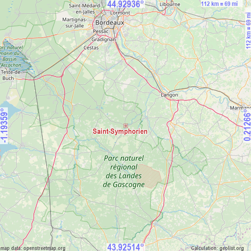
Saint-Symphorien GPS coordinates[2]
44° 25' 45.876" North, 0° 29' 25.692" West
| Map corner | latitude | longitude |
|---|---|---|
| Upper-left | 44.92936°, | -1.19359° |
| Center: | 44.42941°, | -0.49047° |
| Lower-right: | 43.92514°, | 0.21266° |
| Map W x H: | 111.7×111.7 km | = 69.4×69.4mi |
| max Lat: | 51.07786° ⇑84% North |
| Saint-Symphorien: | 44.42941° |
| min Lat: | ⇓16% South 41.3874° |
| min Long | Saint-Symphorie | max Long |
| -5.08615° | -0.49047° | 9.52242° |
| W 16.7%⇐ | ⇒83.3% E |
Elevation
Elevation of Saint-Symphorien is 57 m = 187 ft, and this is 136.7 m = 448 ft below average elevation for this country.
| Max E: |
2333 m = 7654 ft | 79% |
| Avg. | 193.7 m = 635 ft | |
| Saint-Symphorien | 57 m = 187 ft | |
Min E: |
-1 m = -3 ft | 21% |
See also: France elevation on elevation.city.
Geographical zone
Saint-Symphorien is located in North temperate zone (between Tropic of Cancer and the Arctic Circle). Distance of this Northern Tropic circle is 2334.2 km =1450.4 mi to South.| Distance of | km | miles | from Saint-Symphorien |
|---|---|---|---|
| North Pole | 5067 | 3148.5 | to North |
| Arctic Circle | 2461.1 | 1529.3 | to North |
| Tropic Cancer | 2334.2 | 1450.4 | to South |
| Equator | 4940.1 | 3069.6 | to South |


Nearby cities:
15 places around Saint-Symphorien: (largest is in red/bold)
• Bommes
16.8 km =10.4 mi,  39°
39°
• Budos
14.2 km =8.8 mi, 35°
• Hostens
13.8 km =8.6 mi,  300°
300°
• Landiras
16.4 km =10.2 mi,  21°
21°
• Louchats
11.1 km =6.9 mi,  327°
327°
• Luxey
18.6 km =11.6 mi,  187°
187°
• Léogeats
13.5 km =8.4 mi,  46°
46°
• Noaillan
11.4 km =7.1 mi,  59°
59°
• Préchac
11.4 km =7.1 mi,  107°
107°
• Pujols-sur-Ciron
18 km =11.2 mi, 36°
• Roaillan
18.2 km =11.3 mi,  65°
65°
• Saint-Magne
17.2 km =10.7 mi,  308°
308°
• Sauternes
16.5 km =10.3 mi, 45°
• Sore
13.7 km =8.5 mi,  211°
211°
• Villandraut
10 km =6.2 mi, 71°
Sources, notices
• [Note1] Compared only with cities in France existing in our database
• [Src1] Map data: © OpenStreetMap contributors (CC-BY-SA)
• [Src2] Other city data from geonames.org with taken over terms of usage.
• [Src3] Geographical zone / Annual Mean Temperature by Robert A. Rohde @ Wikipedia
