Sargé-lès-le-Mans geodata
Sargé-lès-le-Mans (Pays de la Loire) is a populated place; located in France in Europe/Paris (GMT+2) time zone. With population of 3,656 people, there are 2679 cities with bigger population in this country. Compared to other cities in France, 59.8% of cities are located further ↓South; 76% of cities are located further →East and 61.5% of cities have higher elevation than Sargé-lès-le-Mans. Note1
Administrative division(s):
- Level 1: Pays de la Loire
- Level 2: Sarthe
- Level 3: Arrondissement du Mans
- Level 4: Sargé-lès-le-Mans


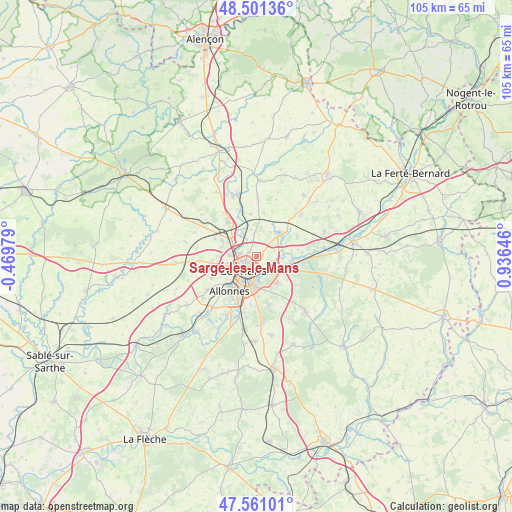
Sargé-lès-le-Mans GPS coordinates[2]
48° 1' 59.988" North, 0° 13' 59.988" East
| Map corner | latitude | longitude |
|---|---|---|
| Upper-left | 48.50136°, | -0.46979° |
| Center: | 48.03333°, | 0.23333° |
| Lower-right: | 47.56101°, | 0.93646° |
| Map W x H: | 104.6×104.6 km | = 65×65mi |
| max Lat: | 51.07786° ⇑40.2% North |
| Sargé-lès-le-Mans: | 48.03333° |
| min Lat: | ⇓59.8% South 41.3874° |
| min Long | Sargé-lès-le- | max Long |
| -5.08615° | 0.23333° | 9.52242° |
| W 24%⇐ | ⇒76% E |
Elevation
Elevation of Sargé-lès-le-Mans is 98 m = 322 ft, and this is 95.7 m = 314 ft below average elevation for this country.
| Max E: |
2333 m = 7654 ft | 61.5% |
| Avg. | 193.7 m = 635 ft | |
| Sargé-lès-le-Mans | 98 m = 322 ft | |
Min E: |
-1 m = -3 ft | 38.5% |
See also: France elevation on elevation.city.
Geographical zone
Sargé-lès-le-Mans is located in North temperate zone (between Tropic of Cancer and the Arctic Circle). Distance of this North polar circle is 2060.4 km =1280.3 mi to North.| Distance of | km | miles | from Sargé-lès-le-Mans |
|---|---|---|---|
| North Pole | 4666.3 | 2899.5 | to North |
| Arctic Circle | 2060.4 | 1280.3 | to North |
| Tropic Cancer | 2734.9 | 1699.4 | to South |
| Equator | 5340.8 | 3318.6 | to South |


Nearby cities:
15 places around Sargé-lès-le-Mans: (largest is in red/bold)
• Aigné
9.2 km =5.7 mi,  292°
292°
• Allonnes
9.2 km =5.7 mi,  217°
217°
• Champagné
7.4 km =4.6 mi,  99°
99°
• Changé
6.5 km =4 mi,  145°
145°
• Coulaines
2.4 km =1.5 mi,  244°
244°
• Fatines
8.6 km =5.3 mi,  80°
80°
• La Bazoge
9.1 km =5.7 mi,  320°
320°
• La Chapelle-Saint-Aubin
5.7 km =3.5 mi,  272°
272°
• La Milesse
8.1 km =5 mi, 294°
• Le Mans
4.2 km =2.6 mi,  210°
210°
• Neuville-sur-Sarthe
5.6 km =3.5 mi,  327°
327°
• Rouillon
7.9 km =4.9 mi,  247°
247°
• Saint-Corneille
9 km =5.6 mi,  65°
65°
• Saint-Saturnin
6.6 km =4.1 mi, 294°
• Trangé
9.2 km =5.7 mi, 265°
Sources, notices
• [Note1] Compared only with cities in France existing in our database
• [Src1] Map data: © OpenStreetMap contributors (CC-BY-SA)
• [Src2] Other city data from geonames.org with taken over terms of usage.
• [Src3] Geographical zone / Annual Mean Temperature by Robert A. Rohde @ Wikipedia
