Fatines geodata
Fatines (Pays de la Loire) is a populated place; located in France in Europe/Paris (GMT+2) time zone. With population of 652 people, there are 12498 cities with bigger population in this country. Compared to other cities in France, 60.1% of cities are located further ↓South; 74.9% of cities are located further →East and 77.3% of cities have higher elevation than Fatines. Note1
Administrative division(s):
- Level 1: Pays de la Loire
- Level 2: Sarthe
- Level 3: Arrondissement de Mamers
- Level 4: Fatines


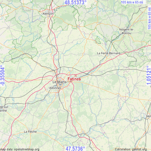
Fatines GPS coordinates[2]
48° 2' 44.916" North, 0° 20' 53.088" East
| Map corner | latitude | longitude |
|---|---|---|
| Upper-left | 48.51373°, | -0.35504° |
| Center: | 48.04581°, | 0.34808° |
| Lower-right: | 47.5736°, | 1.05121° |
| Map W x H: | 104.5×104.5 km | = 64.9×64.9mi |
| max Lat: | 51.07786° ⇑39.9% North |
| Fatines: | 48.04581° |
| min Lat: | ⇓60.1% South 41.3874° |
| min Long | Fatines | max Long |
| -5.08615° | 0.34808° | 9.52242° |
| W 25.1%⇐ | ⇒74.9% E |
Elevation
Elevation of Fatines is 61 m = 200 ft, and this is 132.7 m = 435 ft below average elevation for this country.
| Max E: |
2333 m = 7654 ft | 77.3% |
| Avg. | 193.7 m = 635 ft | |
| Fatines | 61 m = 200 ft | |
Min E: |
-1 m = -3 ft | 22.7% |
See also: France elevation on elevation.city.
Geographical zone
Fatines is located in North temperate zone (between Tropic of Cancer and the Arctic Circle). Distance of this North polar circle is 2059 km =1279.4 mi to North.| Distance of | km | miles | from Fatines |
|---|---|---|---|
| North Pole | 4664.9 | 2898.6 | to North |
| Arctic Circle | 2059 | 1279.4 | to North |
| Tropic Cancer | 2736.3 | 1700.3 | to South |
| Equator | 5342.2 | 3319.5 | to South |


Nearby cities:
15 places around Fatines: (largest is in red/bold)
• Beaufay
11.3 km =7 mi,  5°
5°
• Champagné
3 km =1.9 mi,  205°
205°
• Changé
8.3 km =5.2 mi,  215°
215°
• Connerré
10.9 km =6.8 mi,  83°
83°
• Coulaines
11 km =6.8 mi,  257°
257°
• La Chapelle-Saint-Rémy
10.6 km =6.6 mi,  49°
49°
• Le Breil-sur-Mérize
10.6 km =6.6 mi,  113°
113°
• Lombron
6.4 km =4 mi,  55°
55°
• Montfort-le-Gesnois
5.1 km =3.2 mi, 84°
• Saint-Corneille
2.3 km =1.4 mi,  351°
351°
• Saint-Mars-la-Brière
2.5 km =1.6 mi,  132°
132°
• Sargé-lès-le-Mans
8.6 km =5.3 mi, 260°
• Sillé-le-Philippe
6.8 km =4.2 mi,  1°
1°
• Soulitré
8.9 km =5.5 mi,  115°
115°
• Torcé-en-Vallée
10.2 km =6.3 mi,  20°
20°
Sources, notices
• [Note1] Compared only with cities in France existing in our database
• [Src1] Map data: © OpenStreetMap contributors (CC-BY-SA)
• [Src2] Other city data from geonames.org with taken over terms of usage.
• [Src3] Geographical zone / Annual Mean Temperature by Robert A. Rohde @ Wikipedia
