Feillens geodata
Feillens (Auvergne-Rhône-Alpes) is a populated place; located in France in Europe/Paris (GMT+2) time zone. With population of 3,015 people, there are 3235 cities with bigger population in this country. Compared to other cities in France, 61.9% of cities are located further ↑North; 76.4% of cities are located further ←West and 63.3% of cities have lower elevation than Feillens. Note1
Administrative division(s):
- Level 1: Auvergne-Rhône-Alpes
- Level 2: Département de l'Ain
- Level 3: Arrondissement de Bourg-en-Bresse
- Level 4: Feillens


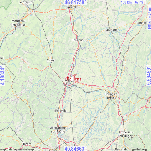
Feillens GPS coordinates[2]
46° 20' 3.336" North, 4° 53' 29.256" East
| Map corner | latitude | longitude |
|---|---|---|
| Upper-left | 46.81758°, | 4.18834° |
| Center: | 46.33426°, | 4.89146° |
| Lower-right: | 45.84663°, | 5.59459° |
| Map W x H: | 108×108 km | = 67.1×67.1mi |
| max Lat: | 51.07786° ⇑61.9% North |
| Feillens: | 46.33426° |
| min Lat: | ⇓38.1% South 41.3874° |
| min Long | Feillens | max Long |
| -5.08615° | 4.89146° | 9.52242° |
| W 76.4%⇐ | ⇒23.6% E |
Elevation
Elevation of Feillens is 186 m = 610 ft, and this is 7.7 m = 25 ft below average elevation for this country.
| Max E: |
2333 m = 7654 ft | 36.7% |
| Avg. | 193.7 m = 635 ft | |
| Feillens | 186 m = 610 ft | |
Min E: |
-1 m = -3 ft | 63.3% |
See also: France elevation on elevation.city.
Geographical zone
Feillens is located in North temperate zone (between Tropic of Cancer and the Arctic Circle). Distance of this North polar circle is 2249.3 km =1397.6 mi to North.| Distance of | km | miles | from Feillens |
|---|---|---|---|
| North Pole | 4855.2 | 3016.9 | to North |
| Arctic Circle | 2249.3 | 1397.6 | to North |
| Tropic Cancer | 2546 | 1582 | to South |
| Equator | 5151.9 | 3201.2 | to South |


Nearby cities:
15 places around Feillens: (largest is in red/bold)
• Bâgé-la-Ville
4.3 km =2.7 mi,  118°
118°
• Bâgé-le-Châtel
4.2 km =2.6 mi,  131°
131°
• Chevroux
7.1 km =4.4 mi,  41°
41°
• Crottet
6.5 km =4 mi,  178°
178°
• Hurigny
7.4 km =4.6 mi,  281°
281°
• Manziat
3.2 km =2 mi,  20°
20°
• Mâcon
5.3 km =3.3 mi,  245°
245°
• Ozan
6.5 km =4 mi, 16°
• Pont-de-Veyle
8.1 km =5 mi, 182°
• Replonges
3.8 km =2.4 mi,  189°
189°
• Saint-André-de-Bâgé
4.4 km =2.7 mi,  146°
146°
• Saint-Laurent-sur-Saône
5 km =3.1 mi,  230°
230°
• Saint-Martin-Belle-Roche
6.1 km =3.8 mi,  333°
333°
• Sancé
4.7 km =2.9 mi, 276°
• Senozan
7.2 km =4.5 mi,  342°
342°
Sources, notices
• [Note1] Compared only with cities in France existing in our database
• [Src1] Map data: © OpenStreetMap contributors (CC-BY-SA)
• [Src2] Other city data from geonames.org with taken over terms of usage.
• [Src3] Geographical zone / Annual Mean Temperature by Robert A. Rohde @ Wikipedia
